About Pearsony Falls and “Rogue Falls”

Pearsony Falls (I’ve also seen it spelled Pearsoney Falls) was kind of our last waterfalling throw-in after having visited the nearby duo of Mill Creek Falls and Barr Creek Falls. In fact, if it wasn’t for the wooden map sign at that other parking lot (suggesting that it was merely a short walk from the other trailhead to Pearsoney Falls), then we probably would have skipped out on it. Nevertheless, as Mom would say, “Since we’re already here, we mind as well do it”, and so by virtue of the existence of this write-up, we’ve done exactly that. This waterfall was basically a short cascade on Mill Creek that was much wider than it was tall (15-25ft in height according to our book by Gregory Plumb). While the falls was pretty graceful and conducive to those silky-smooth tripod-aided long exposure photographs, this excursion also yielded unexpected waterfalling surprises in that we also got to check out the Avenue of the Giant Boulders as well as more cascades on the Rogue River, which Plumb called “Rogue Falls”.
We began our short hike from a surprisingly unsigned large parking area nearby a road bridge over the Rogue River (see directions below). At the far northern end of the parking lot, there was a bathroom as well as a small sign indicating the way to Pearsoney Falls. After a few paces of following the trail, we crossed some larger dirt road and continued straight onto the waterfall trail (there was also a large sign indicating that we were indeed going the right way). After about five minutes of walking (as the trail pretty much followed along Mill Creek downstream), we then were right besides Pearsony Falls. A short scramble onto the banks of the creek yielded the photo you see at the top of this page, though the falls was definitely wider than what I was able to fit onto a single frame of my DSLR camera so I’m imagine an iPhone 6
using Pano mode would do the trick.
After less than ten minutes further down the trail beyond Pearsony Falls, we were then at an opening in the foliage overlooking the Avenue of the Giant Boulders. This was where the Rogue River rushed its way through these huge boulders that were said to have come from the eruption of Mt Mazama (the mountain responsible for Crater Lake) some 7,700 years ago. The force of the Rogue River was evident as many of these huge boulders had moved well downstream over the years (the Prospect Hotel had historical pictures showing some of these same boulders being well upstream back then!). We noticed some people on the other side of the Avenue of the Giant Boulders looking for a place to go bouldering or to find a place where the river was calm enough to cool off. But from where we were at, we were content to get our views then head back up to the trailhead. Overall, the time spent away from the car taking in both Pearsony Falls and this view of the Avenue of the Giant Boulders was about 45 minutes.
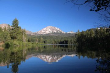
Before we drove off for good, we made one more roadside stop at the bridge spanning the Rogue River. This was where I got out of the car and walked onto the bridge, where I managed to look upstream at a series of rapids and cascades that Gregory Plumb called “Rogue Falls”. As I crossed over to the other side of the bridge looking downstream, I got a more top down view of the Avenue of the Giant Boulders as well as a gorgeous view of the conical Mt McLoughlin in the distance. This roadside stop was probably unsanctioned because there was no pedestrian access on the bridge (so I was taking my chances hoping no car would come whizzing by while I was on it). Gregory Plumb’s book had a photo of an alternate view of “Rogue Falls” showing parts of the cascade beneath the road bridge, but in my limited search, I had neither the time nor the patience to find it.
Related Trip Reports

Related Top 10 Lists
No Posts Found
Related Itineraries
Trip Planning Resources


Nearby Accommodations
This content is for members only. See Membership Options.Featured Images and Nearby Attractions
This content is for members only. See Membership Options.Visitor Comments:
Got something you'd like to share or say to keep the conversation going? Feel free to leave a comment below...No users have replied to the content on this page
Visitor Reviews of this Waterfall:
If you have a waterfall story or write-up that you'd like to share, feel free to click the button below and fill out the form...No users have submitted a write-up/review of this waterfall
Only logged in users can post a comment Please login or sign up to comment