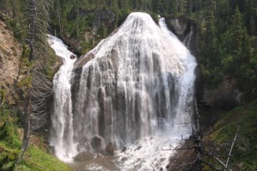
About Ousel Falls

Ousel Falls was a pretty popular yet surprisingly naturesque waterfalling excursion within walking distance from the suburban community of Big Sky. For that reason, I’d bet the falls was Big Sky’s most popular hike. The big payoff was a reportedly 100ft tall waterfall (I suspect it was more like 50ft tall), but in higher flows, I could easily envision the falls being taller than it was wide. The trail provided access to an overlook of the falls, the very base of the falls (where there were a few more cascades further downstream), and the waterfall’s brink. With picnic tables nearby and lots of effort put into the trail maintenance, it was clear to me that this place was set up to make it easy to access for people of all ages. In addition to the falls, the trail meandered through a forested area with a few intermediate cascades as well as some intriguing cliffs hinting that the geologic forces that gave rise to the canyon. The waterfall was named after the ouzel bird or water ouzel (also known as the American dipper), which were small birds resident throughout the Western Northern and Central Americas from Panama to Alaska that would hunt for water insects and small fish by doing dives into the water.
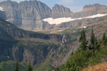
Although I managed to do this hike from the spacious parking lot at the Yellow Mule Trailhead, the well-maintained trails along the canyon carved out by the South Fork of the West Fork of the Gallatin River actually stretched back as far as the Big Sky community itself. The shorter trail that I did was a mere 1.6 miles round trip. If I wanted to, I could have extended the hike another 4 miles round trip (5.6 miles round trip total) by doing the hike from Big Sky and ditching the car if I happened to be visiting or staying there. The trail also continued further into the Custer Gallatin National Forest, where more trails and naturesque experiences could be had to escape civilization. That said, grizzly bears had been spotted in the canyon despite its proximity to Big Sky so it would be wise to carry bear spray in the event of a close encounter that resulted in a bear attack.
From the Ousel Falls Park and Yellow Mule Trailhead (see directions below), I followed a pretty obvious path that skirted along the rim of the canyon right behind the restrooms. The trail from Big Sky continued from my left as I faced the canyon so I went right to continue west in the upstream direction towards the waterfall. The well-used and well-maintained trail (which seemed suitable for runners, folks on bicycle, horseback riders, in addition to hikers) gently descended lower along the canyon rim before reaching a couple of switchbacks descending to a sturdy footbridge across the South Fork of the West Fork of the Gallatin River at the 0.3-mile point. The bridge was full of little plaques containing the names of people who apparently donated to the project that gave rise to the trail I was on. On the other side of the bridge, the trail climbed up past a junction with the Ralph’s Pass Trail as well as the more primitive Yellow Mule Trail before reaching the next plateau. Along the way, the trail narrowed a little more then descended to the next pair of footbridges over the river in the next quarter-mile.
Down at the footbridges, there was an intermediate waterfall as well as a close-up look at the cliffs that hinted at the hard layers of rock that must have given rise to the Ousel Falls. Beyond the footbridges, the trail climbed up to the main waterfall area where there was an overlook right across from the waterfall, a short stepped spur trail leading down to a few picnic tables as well as the base of the waterfall, and a more primitive trail skirting by the brink of the falls. There were also trails continuing further upstream to go deeper into the Custer Gallatin National Forest. In any case, this was my turnaround point, and I wound up spending a leisurely 90 minutes away from the car to really soak it all in. That said, I could easily imagine this up-and-down trail could also take less time if one were in more of a hurry.
Related Trip Reports
Related Top 10 Lists
Related Itineraries
Trip Planning Resources

Nearby Accommodations
This content is for members only. See Membership Options.Featured Images and Nearby Attractions
This content is for members only. See Membership Options.Visitor Comments:
Got something you'd like to share or say to keep the conversation going? Feel free to leave a comment below...No users have replied to the content on this page
Visitor Reviews of this Waterfall:
If you have a waterfall story or write-up that you'd like to share, feel free to click the button below and fill out the form...No users have submitted a write-up/review of this waterfall
Only logged in users can post a comment Please login or sign up to comment