About Natural Bridge on the Rogue River

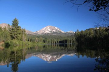
The Natural Bridge on the Rogue River was something we stumbled upon while making the long drive from Medford to Crater Lake National Park. We certainly didn’t anticipate visiting this quirk of Nature, and even when we did, we had debated whether it deserved its own waterfall write-up. Well, as you can see on this page, we decided to consider it a waterfalling attraction mostly because the Rogue River cascaded and sloped in several tiers where it was difficult to tell whether the river was tumbling as a waterfall, cascade, or merely rapids (so we gave it the benefit of the doubt). One thing was for sure, the reason why this place earned the name Natural Bridge was that it was basically where the Rogue River flowed through an ancient lava tube causing most of the raging river to disappear before re-emerging through caves as springs often near or over small waterfalls. It was one of those displays of Nature that was better off being seen in person than captured through photographs (as that photo you see above doesn’t come close to doing it any justice).
The lava tube phenomenon was yet another example of the legacy of volcanism throughout the Southern Cascades, especially in this part of Southern Oregon. While Crater Lake National Park was perhaps the most dramatic example of volcanism, this region was full of other examples from the basalt columns of Salt Creek Falls and Toketee Falls to the sharp peak of Mt Thielsen or even the nearly Mt Rainer-like shape of Mt Shasta further to the south across the state border in the northernmost of California. Interpretive signs here explained that basalt lava flows filled this basin where the outer layers of the lava cooled rapidly, but the insides of the lava flow remained molten and hot until the lava completely drained through leaving behind a lava tube. We’ve seen examples of this on the Big Island of Hawaii where we actually walked through some other examples of lava tubes. Over time, the path of the Rogue River found its way into this basin and ultimately flowed through these lava tubes yielding the Natural Bridge phenomenon that this particular attraction was known for.
We were able to watch the path of the Rogue River from its disappearance to its reappearance and subsequent waterfalls all from a well-developed and paved foot trail (wheelchair accessible). From the large parking area, we walked for less than 10 minutes to a footbridge traversing the raging Rogue River. It was from here that we could clearly see cascades tumbling downstream towards us thereby compelling us to consider this to be a waterfall attraction. As we crossed the bridge and continued to follow the western banks of the Rogue River, more interpretive signs and overlooks became available to us showing things like a few caves where the hidden river re-emerged as powerful springs. Further up along the paved walkway, we’d pass by more interpretive viewpoints showing things like pothole formations as well as blowholes above where the river had disappeared into the lava tube or natural bridge.
At the very end of the paved section of the trail, there was an overlook allowing us to peer right at the spot where the Rogue River disappeared into an inlet leaving behind an eerily empty riverbed for about 200 yards before it would re-appear further downstream at the viewing spots we had seen earlier. One of the interpretive signs here said that Native Americans and early settlers managed to cross the raging Rogue River over this natural bridge. Though I’d imagine that it would only be a matter of time before the pressure and force of the Rogue River would eventually wear away at the covering layer of the lava tube and cause it to collapse. Time will tell when that will happen, but in the mean time, this was one of the more fascinating (and unexpected) features we stumbled upon in our visit to the Southern Cascades. Overall, our visit here lasted around 45 minutes with most of the time spent looking at the attraction in wonder and reading the interpretive signs.
Related Trip Reports

Related Top 10 Lists
No Posts Found
Related Itineraries
Trip Planning Resources


Nearby Accommodations
This content is for members only. See Membership Options.Featured Images and Nearby Attractions
This content is for members only. See Membership Options.Visitor Comments:
Got something you'd like to share or say to keep the conversation going? Feel free to leave a comment below...No users have replied to the content on this page
Visitor Reviews of this Waterfall:
If you have a waterfall story or write-up that you'd like to share, feel free to click the button below and fill out the form...No users have submitted a write-up/review of this waterfall
Only logged in users can post a comment Please login or sign up to comment