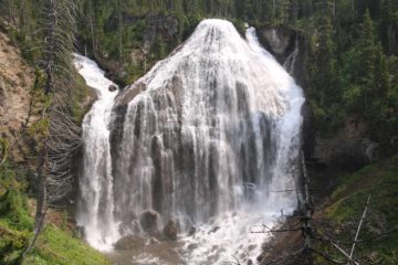
Moyie Falls

Moyie Springs / Bonners Ferry, Idaho, USA

About Moyie Falls


Hiking Distance: 0.3 miles round trip (both views)
Suggested Time: 15-30 minutes

Date first visited: 2017-08-05
Date last visited: 2017-08-05

Waterfall Latitude: 48.73108
Waterfall Longitude: -116.17574

Waterfall Safety and Common Sense

Moyie Falls (not to be confused with the one in Canada) had a lot of potential in terms of it being a must-see waterfall in the panhandle of northern Idaho as it could have been where the Moyie River would crash some 140ft in cumulative height deep within the canyon carved out by the river. However, a hydroelectric facility (possibly powering some of the local lumberyards in Moyie Springs) ensured that only the lower 20-40ft drop was still flowing while the upper 60-100ft drop was dry due to water diversion. Perhaps during the Spring months when the river should have much higher flow (as opposed to our early August visit), then the falls could be enjoyed to full effect. But during our visit, we were only left to wonder what could have been had Nature been allowed to do its thing. That said, the steep walls and overall height of the Moyie River Canyon was impressive, which made it all the more amazing how motorists routinely driving the bridge spanning this gorge shortly downstream of the falls could take this crossing for granted (a testament to the engineering involved to pull this off).

From the sanctioned parking area (see directions below), we walked back up the road for about 0.1 mile going past a hydro facility and eventually reaching the signed overlook behind a fence for Moyie Falls. This viewpoint only yielded the view of the upper drop, where there was the hydro facility right below it. Unfortunately, during our visit, this part of the falls wasn’t flowing. However, we continued walking up the road for another 300ft or so, and that was when we reached an unsigned opening with a view down the steep canyon towards the lower drop of Moyie Falls, which actually was flowing. This was the extent of our experience as there was no safe access into the canyon for a closer and more intimate experience with the waterfalls. Thus, we headed back to the car, and we wound up spending about 25 minutes away from the car (though we really took our time so it could be an even shorter visit than this).

Moyie_Falls_001_08052017
Moyie_Falls_005_08052017
Moyie_Falls_006_08052017
Moyie_Falls_007_08052017
Moyie_Falls_008_08052017
Moyie_Falls_011_08052017
Moyie_Falls_014_08052017
Moyie_Falls_018_08052017
Moyie_Falls_023_08052017
Moyie_Falls_024_08052017
Moyie_Falls_032_08052017


Moyie Falls was within the town of Moyie Springs, Idaho. We’ll pick up the driving directions from Spokane, Washington as well as from Kalispell, Montana since these were our driving routes when we made our visit.

From Spokane, we drove east on the I-90 towards the suburb of Spokane Valley (where we actually overnighted; 10 miles to the east) and ultimately taking the exit 12 for Hwy 95 towards Sandpoint and Moscow (about 31 miles or a little over 30 minutes drive), which was in Coeur d’Alene. Then, we drove about 80 miles (roughly over 90 minutes drive) north to the junction with US2 just north of Bonners Ferry. We then drove east for about 5.5 miles turning right onto the Old US Hwy 2 (also known as East Roosevent Rd).

After about 0.5 miles on East Roosevelt Rd (note the speed limit here was a mere 10mph!), we then turned left onto Canyon View Rd. Then, we followed Canyon View Rd for the next 0.8 miles, which passed by a large lumber yard and some residences and speed bumps, before reaching the sanctioned parking area by a substation. Note that this drive went past the signed viewing area for the Moyie Falls but there was no legal parking there, which was why we had to overshoot it and walk back to the view. Overall, this drive took us about 2 hours, but we actually lost an hour because Idaho was in the Mountain Time Zone so it actually took 3 hours.

From Kalispell, we’d drive west on the US2 for about 131 miles before turning left onto East Roosevelt Rd (shortly after the long bridge over the Moyie River in Moyie Springs). Then, we’d follow the local driving roads as given above. This drive would take about 2.5 hours.

Finally for some geographic context, Bonners Ferry was 32 miles (about 45 minutes drive) north of Sandpoint, 78 miles (over 90 minutes drive) north of Coeur d’Alene, 52 miles (about an hour drive) west of Libby, Montana, 140 miles (2.5 hours drive) west of Kalispell, Montana, and 104 miles (2 hours drive) northeast of Spokane, Washington.

Find A Place To Stay

Sweeps from a couple of different vantage points looking down at the lower drop of Moyie Falls, which was still flowing

Related Top 10 Lists

No Posts Found

Tagged with: moyie springs, boundary county, idaho, idaho panhandle, waterfall, hydroelectricity, dam, diversion, hydro


Visitor Comments:

Got something you'd like to share or say to keep the conversation going? Feel free to leave a comment below...

No users have replied to the content on this page


Share your thoughts about what you've read on this page

You must be logged in to submit content. Refresh this page after you have logged in.

Visitor Reviews of this Waterfall:

If you have a waterfall story or write-up that you'd like to share, feel free to click the button below and fill out the form...

No users have submitted a write-up/review of this waterfall


Have you been to a waterfall? Submit a write-up/review and share your experiences or impressions

Review A Waterfall

Nearest Waterfalls

The Waterfaller Newsletter

The Waterfaller Newsletter is where we curate the wealth of information on the World of Waterfalls website and deliver it to you in bite-sized chunks in your email inbox. You'll also get exclusive content like...

  • Waterfall Wednesdays
  • Insider Tips
  • User-submitted Waterfall Write-up of the Month
  • and the latest news and updates both within the website as well as around the wonderful world of waterfalls


How To Build A Profitable Travel Blog In 4 Steps