About Latourell Falls

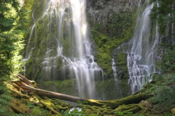
Latourell Falls was a gorgeous waterfall that had the distinction of being the closest major waterfall of the Columbia River Gorge to the City of Portland. It possessed remarkable overhanging columnar basalt cliffs that allowed Latourell Creek to do a 249ft free-falling plunge with no contact with most of the underlying cliff, making it in one of the more unique such waterfalls in the gorge. Even the mighty Multnomah Falls made contact with its underlying cliff for most of its drop, but as you can see in the photos later on in this page, the drop of Latourell Falls was mostly a straight plunge before it smashed into the jumble of broken basalt rocks at its base. Speaking of the basalt, the overhanging cliffs showed obvious hexagonal column formations (hence it was said to be an example of a columnar basalt waterfall). Some of them were vertical while others seemed to have been bent and sheared off. Whether its current form was the result some repeated violent episodes of massive lava flows and massive Ice Age floods, it seemed certain that this waterfall showed plenty of signs of a seemingly cataclysmic past. And even though basalt columns and waterfalls weren’t all that rare around the world (Svartifoss in Iceland and Browns Falls in Australia came to mind as examples of such waterfalls with pronounced basalt columns around it), Latourell Falls could very well be one of the tallest and largest waterfalls of this kind in the world!
Our visits to this waterfall were very straightforward. From the fairly spacious parking lot, we took a well-developed and short path descending towards then along Latourell Creek before reaching the base of the waterfall. The trail continued to bend back away from the falls towards a footbridge spanning the creek for an opportunity to use its railings to steady the camera and take that silky long exposure shot (assuming you didn’t bother bringing a tripod down here). The trail actually kept going and it turned out to be part of a longer 2.1-mile loop hike that encompassed the Upper Latourell Falls (said to be 80-100ft tall). Since I didn’t do that hike, I can’t really say much more about it though I am keen to give that hike a go when the opportunity presents itself.
In addition, there was a paved ramp that ascended from the parking lot to an alternate view of Latourell Falls, which is shown at the top of this page. This particular view was more distant, but it allowed us to experience the falls with more of context as the view was more elevated though the trees seemed to be in the process of obscuring the view as they would continue to grow. The trail continued to ascend beyond this point as part of the other side of the 2.1-mile loop hike encompassing the Upper Latourell Falls. On the way back down to the parking lot, I had to be careful because the ramp was steep enough with enough loose gravel to cause the footing to be a bit slippery.
Related Trip Reports


Related Top 10 Lists
Related Itineraries
Trip Planning Resources


Nearby Accommodations
This content is for members only. See Membership Options.Featured Images and Nearby Attractions
This content is for members only. See Membership Options.Visitor Comments:
Got something you'd like to share or say to keep the conversation going? Feel free to leave a comment below...No users have replied to the content on this page
Visitor Reviews of this Waterfall:
If you have a waterfall story or write-up that you'd like to share, feel free to click the button below and fill out the form...No users have submitted a write-up/review of this waterfall
Only logged in users can post a comment Please login or sign up to comment