About Kootenai Falls

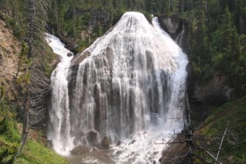
Kootenai Falls was an impressively wide and powerful series of waterfalls and rapids on the Kootenai River. As you can see in the photo at the top of this page, pictures really don’t do this place justice as it doesn’t convey the power and size of the Kootenai River rushing fiercely over a series of drops said to be around 90ft of cumulative height in a stretch covering less than a mile. The main part of the falls actually consisted of a pair of wide segments where the one pictured above dropped visibly 30ft over a width that I’m guessing was at least 200ft. This doesn’t even count the parallel segment where the drop wasn’t as pronounced and it took on more of a cross between rapids and a violent chute of water. In addition to the waterfall, there was a popular suspension bridge or swinging bridge spanning the full width of the Kootenai River another half-mile downstream. It provided access to the shores of the north side of the river as well as a look down at fossilized stromatolytes (ancient algae back when the area was once part of the sea and thus might have been evidence of the earliest signs of life over a billion years ago) towards the southern end of the bridge.
The formation of the falls was said to be due to a succession of phenomena. First, the underlying Belt Supergroup layer of crust was the result of the despoition of quartzites, mudstones, and shale from when the area was an ancient sea floor. Next, tectonic forces caused there to be a folding action where the crust compressed up against a different tectonic plate as they were headed in opposite directions. The Kootenai River exposed the hard rocks of this Belt Supergroup including the tectonic folds and faults that now resulted in the “steps” over which the river flowed and created the waterfalls and cascades. Such violent geologic forces ultimately would give rise to the rugged Rocky Mountains that dominated the Continental Divide separating the ancient seas of the west and the Great Plains to the east (a process that’s still going on now in the Himalayas, where the tallest mountains in the world currently reside). During my visit, I was able to witness several more tiers of the Kootenai Falls further downstream of the main falls, which corroborated the notion of the folding action of the crust over millions of years.
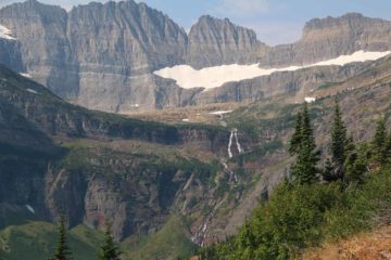
From the spacious parking lot and trailhead right off the US Highway 2 (see directions below), I followed a paved walkway for the first 0.1 mile amongst a forested setting to an obstructed overlook. Then, the trail descended to a caged railway bridge before going down a series of steps eventually leading down to a narrower dirt trail. Next, there was a signposted trail junction at roughly a quarter-mile from the trailhead. I kept right at this junction to get right up to the overlook of the main part of Kootenai Falls in another 1/8-mile. Along the way, there were several “social trails” that were well-used that also led to alternate views of the main falls as well as views of more waterfalls and cascades further downstream.
Once I had my fill of these viewing areas, I then returned to the main trail and hiked back past the trail junction before continuing another quarter-mile towards the popular Swinging Bridge. This was my turnaround point, but I saw plenty of people going across the bridge to access a small “beach” area on the shores of the river further upstream. I also regretted not paying closer attention to the fossilized stromatolytes close to the southern end of the suspension bridge. In any case, when all was said and done, I wound up spending a little over 60 minutes away from the car, but it was very easy to spend an entire afternoon here as I witnessed many others do, especially on a warm day like when we made our visit. And speaking of warm, Julie bought some huckleberry ice cream from the trailhead grill, and she swore that we hadn’t had as good quality for the remainder of the trip!
Related Trip Reports
Related Top 10 Lists
Related Itineraries
Trip Planning Resources

Nearby Accommodations
This content is for members only. See Membership Options.Featured Images and Nearby Attractions
This content is for members only. See Membership Options.Visitor Comments:
Got something you'd like to share or say to keep the conversation going? Feel free to leave a comment below...No users have replied to the content on this page
Visitor Reviews of this Waterfall:
If you have a waterfall story or write-up that you'd like to share, feel free to click the button below and fill out the form...No users have submitted a write-up/review of this waterfall
Only logged in users can post a comment Please login or sign up to comment