Jump Creek Falls

Sands Basin / Marsing / Nampa, Idaho, USA

About Jump Creek Falls


Hiking Distance: 1/2-mile round trip
Suggested Time: 30 minutes

Date first visited: 2013-04-25
Date last visited: 2013-04-25

Waterfall Latitude: 43.47717
Waterfall Longitude: -116.92512

Waterfall Safety and Common Sense

Jump Creek Falls was seemingly a locals’ kind of waterfall, especially since we had to navigate through a maze of private property to even find this gem not far from Boise, Idaho. What really made this waterfall stand out in our minds was the combination of the overhanging, colorful, and narrow walls of Jump Creek Canyon, which surrounded the falls itself as well as the short hike to get there. Indeed, the waterfall was merely the sideshow to the short but attractive canyon that very much reminded us of something we would have expected to see in the deserts of the American Southwest instead of Southwestern Idaho.

Jump Creek Falls itself was said to be around 50ft tall. We happened to see it in moderate to low flow during our late April 2013 visit on a pretty hot day in the mid 80s. So the shadiness of our late afternoon visit to the falls certainly provided us with some kind of relief from the heat in the otherwise dry, dusty, and desolate canyonlands.

Aside from one other pair of ladies who were on their way out, Julie and I had the falls to ourselves. So the only sounds we heard (besides the ones we’ve made walking about and snapping photos) were that of some local pidgeons and the white noise of the Jump Creek Falls itself splashing into its calm plunge pool.

Jump_Creek_007_20130425
Julie walking within the confines of Jump Creek Canyon
There were large boulders strewn about the alcove, which probably fell from the cliffs above us. There was even a part of the fallen rocks where there was a tunnel-like hole leading to the rest of the alcove for a more direct view of the falls. Nonetheless, these fallen rocks reminded us of the inherent danger as parts of the cliffs could give at any moment. So as much as we wanted to stick around here for a while, we were always cognizant of the rockfall danger.

The walk from the mouth of Jump Creek Canyon to the falls was merely about a quarter-mile. We had to cross the creek once, but given the tame waterflow, we only needed to rock hop to get across without the risk of getting our feet wet. Speaking of the waterflow, apparently early to mid Spring would be the most optimal times to view this waterfall because it could be trickling or dry by Summer (depending on the snow pack and melt).

Many of the canyon walls seemed to feature some holes, alcoves, or even some tiny natural arches. I recalled seeing one on a cliff above Jump Creek Falls that appeared to be a pinhole type of arch. Meanwhile, there was an arch shaped like a jug handle above the walking trail as well. Given the height of the cliff walls and their close proximity around us, it almost felt as if these vertical walls were closing in on us as we were at the base of the falls. That was how tight this short but gorgeous canyon was.

We said this was a locals waterfall because on our way out, we noticed there were people starting to head to the canyon itself. There were a few young men smoking and chilling out by some ugly graffiti in one dark alcove near the mouth of the canyon when we were leaving. And given how tricky it was to even find the correct access roads to get to the falls, it would make sense that only locals would have the confidence of knowing which roads to take to get here quickly. Indeed, it felt as if we had stumbled into some secret place.

Overall, we spent about an hour here to encompass the walking and photo taking.

Back at the trailhead, we noticed that there was a trail that went higher up the canyon. After we were done with our trip and had read a little more about it, we would later find out that the high and dry path led to an overlook on a recently improved trail. I guess we’ll have to come back here one of these days to check out the view from up there.

Jump_Creek_053_20130425
Jump_Creek_052_20130425
Jump_Creek_051_20130425
Jump_Creek_003_20130425
Jump_Creek_009_20130425
Jump_Creek_010_20130425
Jump_Creek_011_20130425
Jump_Creek_013_20130425
Jump_Creek_020_20130425
Jump_Creek_038_20130425
Jump_Creek_048_20130425
Jump_Creek_050_20130425


Jump Creek Falls was probably the closest waterfall excursion that we could find from the city of Boise, Idaho. That was the main reason why we chose to do it.

From Boise, we drove on the I-84 west to the Nampa exit (Exit 33A). That exit put us on the Hwy 55, which passed through the bustling suburb of Nampa. There was some traffic in the Nampa area due to merging lanes before Hwy 55 passed through the Snake River Valley Wine Region between Nampa and Marsing.

We followed Hwy 55 on through the town of Marsing, where the highway eventually junctioned with the Hwy 95. We turned left onto Hwy 95 and drove for about 2.5 miles to the easy-to-miss Poison Creek Road on our right.

Jump_Creek_054_20130425
A key landmark for us was the intersection of Poison Creek Road and Jump Creek Road
We then followed Poison Creek Road passing between lots of farms for about 3.5 miles or so until we reached a stop sign at a four-way intersection with Jump Creek Road. We turned left onto Jump Creek Road and briefly followed it until the pavement ended where we were confronted with a fork (one that went straight into someone’s ranch and one that turned right past a cattle guard onto a sign that indicated there was a single-lane bridge). I didn’t recall seeing this, but the Bureau of Land Management’s website indicated there were power transmission lines here.

So we took the fork on the right, crossed over the single-lane bridge, and avoided the private driveway on the left. Shortly thereafter, the unpaved road we were following did a curve that went left towards the Jump Creek Recreation Area. It was at this point that we started to notice some Jump Creek signs to help us stay on the correct roads so as to not trespass.

Jump_Creek_001_20130425
On the unpaved road leading towards the beautiful Jump Creek Canyon
The road would eventually lead to the mouth of Jump Creek Canyon. I recalled there were a couple of confusing forks. The first fork was just past a cattle guard by a “Pack In, Pack Out” sign, where we stayed to the left. The last fork was actually by a “No Shooting, Safety Zone” sign where we stayed left and descended a rutted road to the car park right at the mouth of the canyon.

Had we stayed right at the last fork, there was another car park that was probably for the Upper Overlook, which we didn’t do (though we wish we had in hindsight).

Overall, the drive was roughly an hour from Meridian and a little over an hour from Boise.

It’s worth noting that the directions we followed largely followed Gregory Plumb’s guidebook about waterfalls in the Pacific Northwest. The Bureau of Land Management’s website had a slightly different route where instead of taking Poison Creek Road south of the junction of US95 and Hwy 55, they advocated taking Cemetery Road 1.5 miles west of that junction on US95. That road would eventually lead to a T-intersection with a stop sign where you turn left, and then continue as the road becomes Jump Creek Road. The part where the paved road becomes unpaved still follows the same directions as we gave it earlier.

Find A Place To Stay

nearly 360-degree sweep starting with a peek-a-boo hole or arch above the falls, then panning down along the falls before sweeping over and around as the camera was pointing at the surrounding cliffs closing in on the cove we were in. The movie ends with a little tunnel or arch right next to us.


360-degree counterclockwise sweep along the cliff tops towering over us. In the sweep is a bottom up panning of the falls itself.

Related Top 10 Lists

No Posts Found

Tagged with: sands basin, marsing, nampa, boise, idaho, waterfall, owyhee, sunnyslope, wine region


Visitor Comments:

Got something you'd like to share or say to keep the conversation going? Feel free to leave a comment below...

No users have replied to the content on this page


Share your thoughts about what you've read on this page

You must be logged in to submit content. Refresh this page after you have logged in.

Visitor Reviews of this Waterfall:

If you have a waterfall story or write-up that you'd like to share, feel free to click the button below and fill out the form...

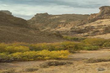
Jump Creek after the Soda fires October 20, 2015 10:53 pm by Louis Ruth - In July and August the Soda fires burned over 300,000 acres from Jordan valley to Marsing Idaho. One of the areas I visit as a photographer is Jump Creek Falls outside of Marsing. I thought it was spectacular that the trees survived the fires that follow the Canyon and the Fall colors show through brilliantly. ...Read More

Have you been to a waterfall? Submit a write-up/review and share your experiences or impressions

Review A Waterfall

Nearest Waterfalls

The Waterfaller Newsletter

The Waterfaller Newsletter is where we curate the wealth of information on the World of Waterfalls website and deliver it to you in bite-sized chunks in your email inbox. You'll also get exclusive content like...

  • Waterfall Wednesdays
  • Insider Tips
  • User-submitted Waterfall Write-up of the Month
  • and the latest news and updates both within the website as well as around the wonderful world of waterfalls


How To Build A Profitable Travel Blog In 4 Steps