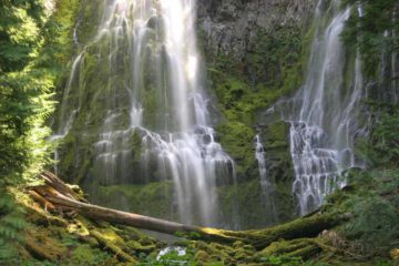
About Elowah Falls

Elowah Falls was another one of the distinct plunging waterfalls situated in John B. Yeon State Park more towards the eastern end of what we perceived to be the “waterfalls area” along the historical highway detour of the Columbia River Gorge. Because of its plunging characteristic and overhanging vertical cliffs (clear evidence of past lava flows giving rise to these hard layers of rock), this waterfall reminded me very much of Latourell Falls. In fact, if I took a glancing look at photos of the two waterfalls, I could easily get them confused without examining them a bit more carefully. Nevertheless, in this instance, the McCord Creek was said to drop 213ft (though I’ve seen this figure as high as 289ft), and it required a little bit more of a hike to access it (though not by much as it was said to be about 1.6 miles round trip). Those factors alone made this waterfall a relatively hidden gem as it was far less popular than most of the drive-by waterfalls in the area. Since the falls was on McCord Creek, at one point, it was referred to as the McCord Creek Falls (there was an Upper McCord Creek Falls further upstream reached by a separate hike) before it was renamed to Elowah by a mountaineering organization based in Portland called the Mazamas.
The trail to Elowah Falls was within the boundaries of the John B. Yeon State Park (I guess it’s now called the John B. Yeon Scenic Corridor). Yeon was a Portland businessman who was instrumental in the completion of the Columbia River Highway at a time when the project was plagued with mismanagement and cost overruns. He apparently took personal ownership of the project as a volunteer roadmaster for Multnomah County, but his devotion to the project costed him his own business endeavors and investments. Nevertheless, the existence of the road connecting most of the Columbia River Gorge waterfalls, which most motorists take for granted these days, could be attributed to Yeon’s efforts.
From the trailhead right next to a freeway entrance for the I-84 (see directions below), the trail immediately climbed past an old water tank then switched back and continued rising towards a trail junction in 0.4 miles. At the junction, I kept left to continue onwards to Elowah Falls. Going right at this junction would lead up a steep trail to Upper McCord Creek Falls, which would nearly double the round-trip length of the overall hike if I were to add it to this hike. The trail would continue to gently climb for the next 0.1-mile before starting to descend some narrow ledges then resuming alongside the McCord Creek. When I first did this hike in late March 2009, the trail veered left then switched back along McCord Creek to the falls. However, on my second visit, the trail was re-routed to the right and made a sharp switchbacking descent on an eroded hillside. I’m sure this part of the trail would be in constant maintenance as conditions seemed to be in a perpetual state of flux here.
Next, the narrow ledge trail meandered alongside McCord Creek in a more gradual descent eventually leading to a footbridge crossing right before the base of the Elowah Falls. In high flow (like it was when Julie and I first visited in late March 2009), it was tremendously misty, windy, and slippery around the footbridge, but in lower flow (like on my second visit in August 2017), I was better able to appreciate the open amphitheater as the scene was less turbulent. Thus, I could get a closer look up at the overhanging cliffs giving rise to the waterfall’s freefalling plunge. But unlike Latourell Falls, the cliffs seemed to have a less pronounced columnar appearance. With all the rocks strewn at the base as well as some giant boulders strewn next to the footbridge, I was reminded of where they came from and how prone rock slides were here. I even noticed what appeared to be a tiny cave further upslope from one of the rock slides, where a thin ephemeral waterfall was still flowing.
Anyways, since this waterfall required a 3/4-mile hike (or 0.8-mile based on the signage) to get here, it wasn’t nearly as busy as at Latourell Falls. So it was a relaxing and enjoyable visit. After having my fill of this falls, I went back the way I came and wound up spending under an hour away from the car.
Related Trip Reports

Related Top 10 Lists
Related Itineraries
Trip Planning Resources


Nearby Accommodations
This content is for members only. See Membership Options.Featured Images and Nearby Attractions
This content is for members only. See Membership Options.Visitor Comments:
Got something you'd like to share or say to keep the conversation going? Feel free to leave a comment below... Gorgeous (Elowah Falls) June 14, 2010 12:46 am - One of the most rewarding shorter/easier hikes that I've done. It's definitely worth the very short patches of barely steep inclines. There is a path less traveled, however it makes for an amazing hike when you happen to visit this extraordinary beauty... A bit more of a strenuous hike toward the top but this little… ...Read More
Visitor Reviews of this Waterfall:
If you have a waterfall story or write-up that you'd like to share, feel free to click the button below and fill out the form...No users have submitted a write-up/review of this waterfall
Only logged in users can post a comment Please login or sign up to comment