Leutaschklamm Waterfall

Mittenwald / Garmisch-Partenkirchen District, Bavaria (Bayern), Germany

About Leutaschklamm Waterfall


Hiking Distance: 2km round trip
Suggested Time: 45-60 minutes

Date first visited: 2018-06-27
Date last visited: 2018-06-27

Waterfall Latitude: 47.42738
Waterfall Longitude: 11.2531

Waterfall Safety and Common Sense

The Leutaschklamm Waterfall was at the bottom of the impressive Leutaschklamm Gorge, which was right at the Germany and Austria border near Mittenwald, Germany. Although the impressive gorge itself with its high vertigo-inducing catwalks and a bridge that traversed the deep chasm was free to explore, the most interesting part of the gorge including the 23m waterfall required a fee. Naturally, I did the paid part of the gorge, and here’s how it went.

From the street parking spaces at the southern end of Mittenwald (see directions below), I walked along the Innsbruckerstrasse across a bridge over the Isar River. Just on the other side of the bridge, I crossed the road and entered a small alleyway called Am Köberl. I then followed this gentle and flat path for about 800m as it followed along the Leutascher Ache and revealed a beautiful valley backed by tall mountains and fronted by farms with green pastures.

Leutaschklamm_031_06272018
Hiking within the Leutaschklamm in pursuit of the 23m waterfall
Eventually, I reached a kiosk at the mouth of the Leutaschklamm Gorge just past a trail junction where a separate path steeply climbed towards the elevated catwalks and bridges as that would eventually hook up with the trail coming from the car park on the Austria side via the so-called Gleisterklamm (or Spirit Gorge). In any case, I went up to the kiosk, paid my 2 euro admission, and then promptly went up a boardwalk the followed along the contour of the narrow but deep gorge.

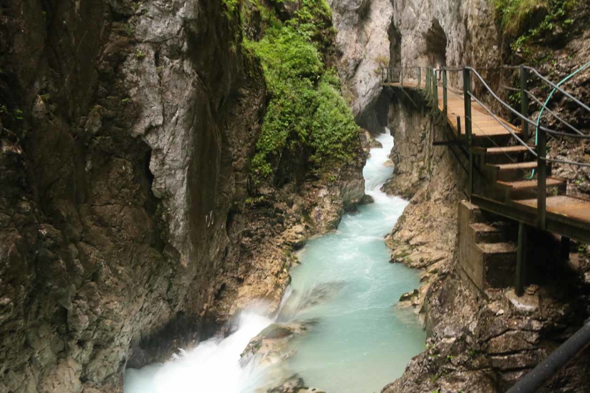
After about 200m within the gorge, the boardwalk reached a dead-end right in front of the partially visible Leutaschklamm Waterfall. Due to the tight confines of the chasm combined with the reverberating properties of the hard rock walls, the sound of the crashing water was deafening. This was my turnaround point, and it could have been the end of a short excursion. However, I opted to extend my visit and do a longer loop hike on the so-called Goblin Trail, which added another 1.9km to the overall excursion.

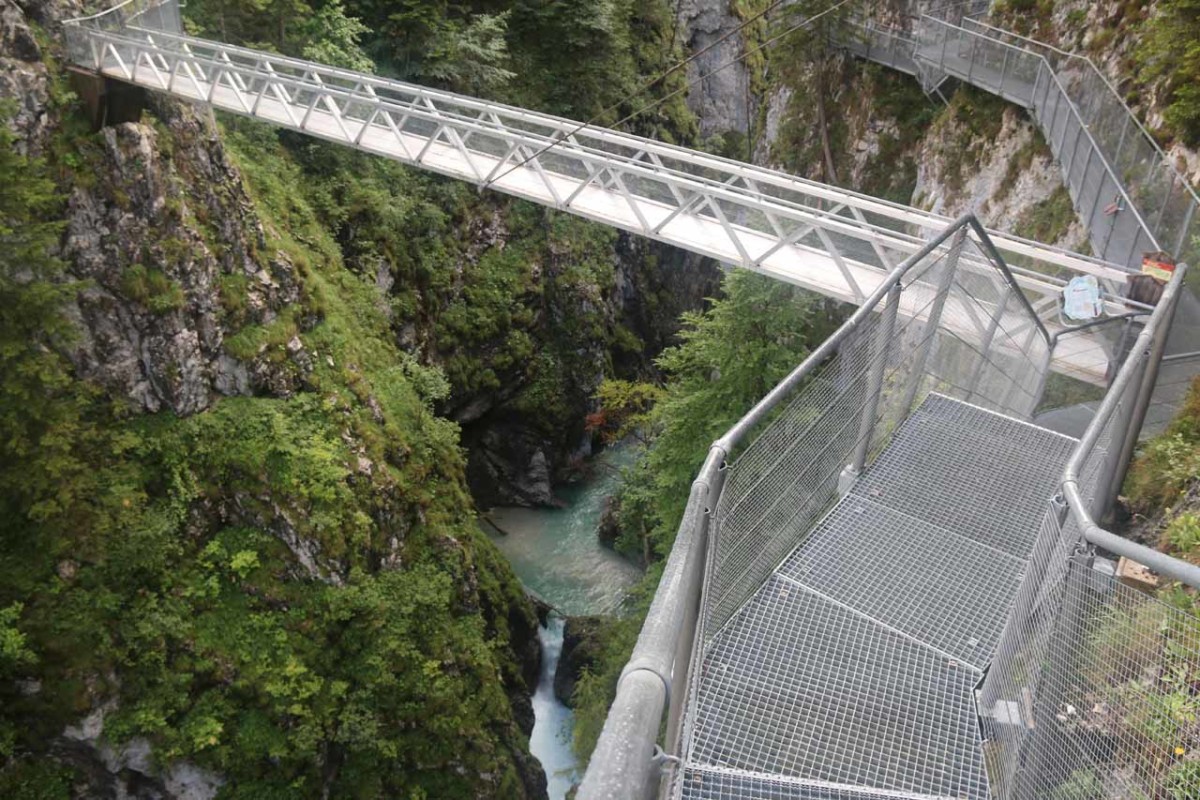
So back at the kiosk, I then took the ascending trail that went up several switchbacks where each one had an interpretive sign talking about the gorge and its creation dating back to the previous Ice Ages. After the steep climb topped out, it eventually descended a series of steps on steel catwalks leading down to a junction right at one end of an impressive bridge spanning the gorge itself.

Leutaschklamm_139_06272018
Looking down into the Leutaschklamm Gorge from the bridge traversing its span along the so-called Goblin Trail
I could have continued straight and really extend the hike for at least another 3km to check out the Mountain Spirit Gorge Trail (leading to the Leutasch Gorge Kiosk and car park on the Austria side), but I opted to cross the bridge instead. At this vantage point, I was able to see more smaller cascades way down in the chasm while also getting teasing glimpses further downstream towards the Karwendelspitze and wall on the opposite side of the valley.

Beyond the bridge, the path ascended a little more before descending down a forested track past a farm, and ultimately circling back to the mouth of the Leutaschklamm Gorge. From there, I wrapped up the excursion along the Am Köberl Road before returning to the Innsbruckerstraße and parking area back on the other side of the Isar River.

Overall, if I had just done the waterfall on its own, then this excursion should take no more than an hour. However, since I extended it with the Goblin Trail Loop, I wound up spending almost two hours away from the car. The bad weather also slowed things down a bit.

Leutaschklamm_003_06272018
Leutaschklamm_007_06272018
Leutaschklamm_014_06272018
Leutaschklamm_079_06272018
Leutaschklamm_025_06272018
Leutaschklamm_038_06272018
Leutaschklamm_041_06272018
Leutaschklamm_044_06272018
Leutaschklamm_058_06272018
Leutaschklamm_090_06272018
Leutaschklamm_110_06272018
Leutaschklamm_134_06272018
Leutaschklamm_154_06272018
Leutaschklamm_156_06272018
Leutaschklamm_165_06272018
Leutaschklamm_174_06272018
Leutaschklamm_197_06272018
Leutaschklamm_204_06272018
Leutaschklamm_209_06272018
Leutaschklamm_227_06272018
Leutaschklamm_230_06272018


The Leutaschklamm Waterfall and Gorge was probably best accessed from the town of Mittenwald, Germany. Even though there was a more official (and more expensive) car park further up the mountain road on the Austria side, that also extended the walk unnecessarily in my mind. I’ll describe the directions from the city of Garmisch-Partenkirchen. You can use apps like Google Maps to pick up directions to the city from other towns and cities further away.

So from city center of Garmisch-Partenkirchen, we drove south then east along the B2 (Hauptstraße), and followed this road for about 11km. We then left the B2 for the St2542 at the town of Klais. We followed the St2542 as it entered the town of Mittenwald, then we continued past the town center via Schöttkarstraße, which became the Karwendelstraße, and ultimately the Innsbruckerstraße.

Leutaschklamm_238_06272018
Looking downstream from the bridge over the Isar River on the southern end of Mittenwald
Towards the southern end of town, the Innsbruckerstraße crossed a bridge over the Isar River, and we managed to find parking a short distance further. Overall, this drive took us on the order of 25 minutes.

Alternatively, we could have also parked at the car park on the Austria side. To get there from where we parked the car as described above, we’d backtrack across the bridge over the Isar River on Innsbruckerstraße, then we’d turn left onto the Leutascherstraße (it was a steeply climbing mountain road on the left as we head north on Innsbruckerstraße). Then, we’d follow this road for about 3km before reaching the Leutascher Gleisterklamm car park on the left.

The parking on the Austria side was pay and display costing 5 euros for the day.

For context, Garmisch-Partenkirchen was about 23km (around a half-hour drive) northeast of Ehrwald, Austria, 59km (about an hour drive) east of Füssen, 64 km (a little over an hour drive) north of Innsbruck, Austria, and 89km (well over an hour drive) south of Munich.

Find A Place To Stay

Semi-circular sweep examining the lone waterfall in Leutaschklamm


Checking out some waterfalls from the suspension bridge high over the Leutaschklamm

Related Top 10 Lists

No Posts Found

Trip Planning Resources


Nearby Accommodations


Tagged with: mittenwald, garmisch-partenkirchen, leutasch, spirit gorge, leutascher ache, karwendel, am koberl, germany, waterfall


Visitor Comments:

Got something you'd like to share or say to keep the conversation going? Feel free to leave a comment below...

No users have replied to the content on this page


Share your thoughts about what you've read on this page

You must be logged in to submit content. Refresh this page after you have logged in.

Visitor Reviews of this Waterfall:

If you have a waterfall story or write-up that you'd like to share, feel free to click the button below and fill out the form...

No users have submitted a write-up/review of this waterfall


Have you been to a waterfall? Submit a write-up/review and share your experiences or impressions

Review A Waterfall

Nearest Waterfalls

The Waterfaller Newsletter

The Waterfaller Newsletter is where we curate the wealth of information on the World of Waterfalls website and deliver it to you in bite-sized chunks in your email inbox. You'll also get exclusive content like...

  • Waterfall Wednesdays
  • Insider Tips
  • User-submitted Waterfall Write-up of the Month
  • and the latest news and updates both within the website as well as around the wonderful world of waterfalls


How To Build A Profitable Travel Blog In 4 Steps