Cascate del Dardagna

Madonna dell'Acero / Lizzano in Belvedere, Emilia-Romagna Province, Italy

About Cascate del Dardagna


Hiking Distance: 3-4km round trip
Suggested Time: 2.5-3 hours

Date first visited: 2013-05-26
Date last visited: 2013-05-26

Waterfall Latitude: 44.14045
Waterfall Longitude: 10.81344

Waterfall Safety and Common Sense

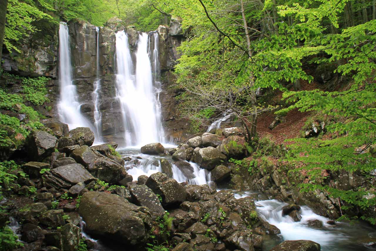
Le Cascate del Dardagna (The Waterfalls of the Dardagna) were a series of intermediate-sized waterfalls tumbling in succession for a reported cumulative height of 200m or so. I don’t think there was a safe way to see the entire waterfall in one go, but the trail went alongside the entire waterfall providing the opportunity to experience at least three of its main tiers from up close.

What stood out about this waterfall experience was that the entire hike truly felt like I was back in Nature. Nestled in the mountains of the Appennino Bolognese (Bolognian Apennines), the trail was serene and uncrowded as it was dominated by trees and the sounds of rushing water (coming from the Dardagna River as well as tributaries feeding it). Under the jurisdiction of the Parco Regionale Corno alle Scale, it was also refreshing to see signs saying “Rispetta La Natura” (Respect Nature), where it seemed this respect was evident during the hike.

In fact, while most of Italy appeared to be developed in some way shape or form, places like this really stood out to us. With the falls being within a reasonable day trip from the more famous cities such as Florence (80km), Bologna (70km), Modena (70km), and even Pisa (120km), the Nature would provide a nice contrast and mix up with the crowds and the historical sites that the urban centers would feature.

Cascate_del_Dardagna_049_20130526
The first main waterfall on the Dardagna
The hike began from the Santuario di Madonna dell’Acero (the Sanctuary of Madonna of the Acero), which was an intriguing building right at the trailhead within the hamlet of Madonna dell’Acero (see directions below). From there, I hiked up along a wide and unpaved road that could only be driven by authorized vehicles as the road weaved between a few buildings. After a gate, the path then flattened out and started to descend amidst more naturesque forest scenery.

At each trail junction, there were numbered red-white arrow signs, and I basically had to remain on the trail 331 to continue towards Cascate del Dardagna. The gradually descending and narrowing path crossed a couple of bridges (I recalled one had a small cascade by it) before the trail eventually started to climb steeply alongside the rushing Dardagna River.

After a few more minutes of uphill hiking on the trail perched on a narrow ledge above the Dardagna, the trail then crossed a bridge before a cascade on a separate tributary feeding the Dardagna. Not long after that bridge, I eventually encountered the first and bottommost of the Dardagna Waterfalls (roughly 30 minutes from the trailhead).

Cascate_del_Dardagna_070_20130526
The second main waterfall on the Dardagna
This 15m tall bottom tier was probably the most photographed of the waterfall’s sections as it had a somewhat vertical drop with the falls itself being segmented or split. Although there was a bridge across the Dardagna leading to another trail (which I didn’t take), the waterfall trail that I stuck with continued further upstream in a much steeper and narrower ascent (though there were steps and handrails to assure me that I wasn’t doing anything terribly dangerous).

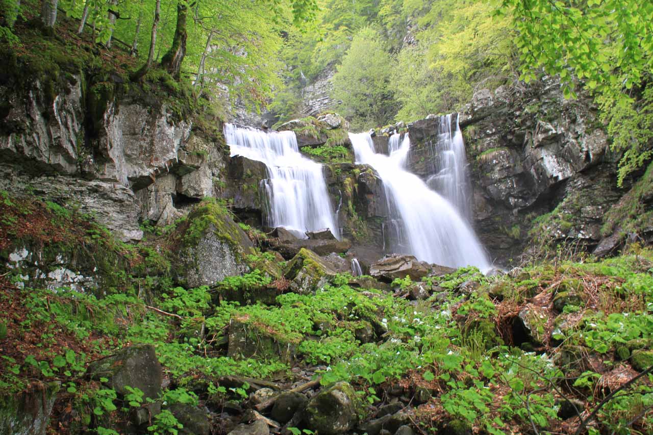
After another 20 minutes of climbing above the first waterfall as well as some other steep intermediate tiers, the trail then approached the second waterfall. This one was probably on the order of 10m, and it also had a somewhat segmented appearance like the first waterfall. There were also lots of foliage and large rocks in a fairly flat opening right in front of the falls, which made it possible to scramble a bit (with care) for a closer look.

Next, the trail then ascended more steep steps, but after five more minutes of this, the trail terminated at the base of the third waterfall. This particular falls was probably a little taller than the first waterfall I saw, but it possessed a more conventional mountain cascade shape (see photo at the top of this page) while also providing an interesting panorama of the downstream scenery over the top of the second waterfall. I’m sure this would’ve been a pretty neat place to take a breather and maybe even have a picnic lunch, but it was also happened to be hailing so I had to hasten my visit.

Since the majority of the hike was downhill back to the trailhead, I went much faster on the way back. Although I’d imagine this hike would typically take two hours round trip, I ended up taking about 100 minutes doing this hike solo under some threatening weather conditions.

Cascate_del_Dardagna_007_20130526
Cascate_del_Dardagna_008_20130526
Cascate_del_Dardagna_010_20130526
Cascate_del_Dardagna_002_20130526
Cascate_del_Dardagna_013_20130526
Cascate_del_Dardagna_014_20130526
Cascate_del_Dardagna_018_20130526
Cascate_del_Dardagna_019_20130526
Cascate_del_Dardagna_021_20130526
Cascate_del_Dardagna_023_20130526
Cascate_del_Dardagna_025_20130526
Cascate_del_Dardagna_028_20130526
Cascate_del_Dardagna_032_20130526
Cascate_del_Dardagna_033_20130526
Cascate_del_Dardagna_044_20130526
Cascate_del_Dardagna_055_20130526
Cascate_del_Dardagna_062_20130526
Cascate_del_Dardagna_070_20130526
Cascate_del_Dardagna_075_20130526
Cascate_del_Dardagna_077_20130526
Cascate_del_Dardagna_090_20130526
Cascate_del_Dardagna_093_20130526
Cascate_del_Dardagna_101_20130526
Cascate_del_Dardagna_103_20130526
Cascate_del_Dardagna_104_20130526
Firenze_064_20130526
Siena_120_20130525
Siena_015_20130525


First of all, I have to really thank the kind folks at the Rifugio Segavecchia for providing me with a detailed map as well as very helpful hints on the driving route I should have taken to get to the Cascate del Dardagna. They were also very patient with my Italian during the entire conversation. Our GPS had put us on the wrong road that ultimately led us on a very narrow single-lane road which ended at this mountain lodge. It ended up being a fairly costly 40-minute detour, but at least with their help, our waterfalling experience along with this writeup became possible.

Anyways, we’ll describe the correct route we should have taken in the first place.

From Florence, we took the A11 autostrada towards the Pistoia exit. Then we headed north on SS64 (SS = Strada Statale or what might be considered a state highway) towards the town of Silla. We then turned left onto John Fitzgerald Kennedy Road, which became SP324 (SP = Strada Provinciale or provincial road). We then followed this road towards the town of Lizzano in Belvedere.

The main road continued through Lizzano in Belvedere, then we deviated from the main road at Villagio Europa towards Vidiciatico. After continuing on the main road passing through Vidiciatico and then La Ca, we then took a road towards Madonna dell’Acero.

Although we saw there was a parking lot along the main road near a fairly hidden visitor center, we actually found additional (albeit very limited) parking next to the Sanctuary of Madonna dell’Acero. The hike began from there.

To give you a sense of context, Madonna dell’Acero was 102km (roughly 2 hours drive) north of Florence, 120km (about 2.5 hours drive) northeast of Pisa, 105km (2 hours drive) northeast of Lucca, 177km (about 3 hours drive) north of Siena, and 82km (about 2 hours drive) south of Bologna.

Find A Place To Stay

Sweeping along the trail until it ends at the lowermost of the Dardagna Waterfalls


Left to right sweep of the middle tiers of the falls


Right to left sweep of the uppermost waterfall starting downstream then ending at the falls

Related Top 10 Lists

No Posts Found

Trip Planning Resources


Nearby Accommodations


Tagged with: emilia, romangna, bologna, florence, firenze, madonna dell'acero, lizzano in belvedere, italy, waterfall, dardagna, corno alle scale


Visitor Comments:

Got something you'd like to share or say to keep the conversation going? Feel free to leave a comment below...

No users have replied to the content on this page


Share your thoughts about what you've read on this page

You must be logged in to submit content. Refresh this page after you have logged in.

Visitor Reviews of this Waterfall:

If you have a waterfall story or write-up that you'd like to share, feel free to click the button below and fill out the form...

No users have submitted a write-up/review of this waterfall


Have you been to a waterfall? Submit a write-up/review and share your experiences or impressions

Review A Waterfall

Nearest Waterfalls

The Waterfaller Newsletter

The Waterfaller Newsletter is where we curate the wealth of information on the World of Waterfalls website and deliver it to you in bite-sized chunks in your email inbox. You'll also get exclusive content like...

  • Waterfall Wednesdays
  • Insider Tips
  • User-submitted Waterfall Write-up of the Month
  • and the latest news and updates both within the website as well as around the wonderful world of waterfalls


How To Build A Profitable Travel Blog In 4 Steps