Cascade du Ray-Pic

Ardeche, Rhone-Alpes, France

About Cascade du Ray-Pic


Hiking Distance: 1.5km round trip
Suggested Time: 45-60 minutes

Date first visited: 2012-05-10
Date last visited: 2012-05-10

Waterfall Latitude: 44.79203
Waterfall Longitude: 4.26827

Waterfall Safety and Common Sense

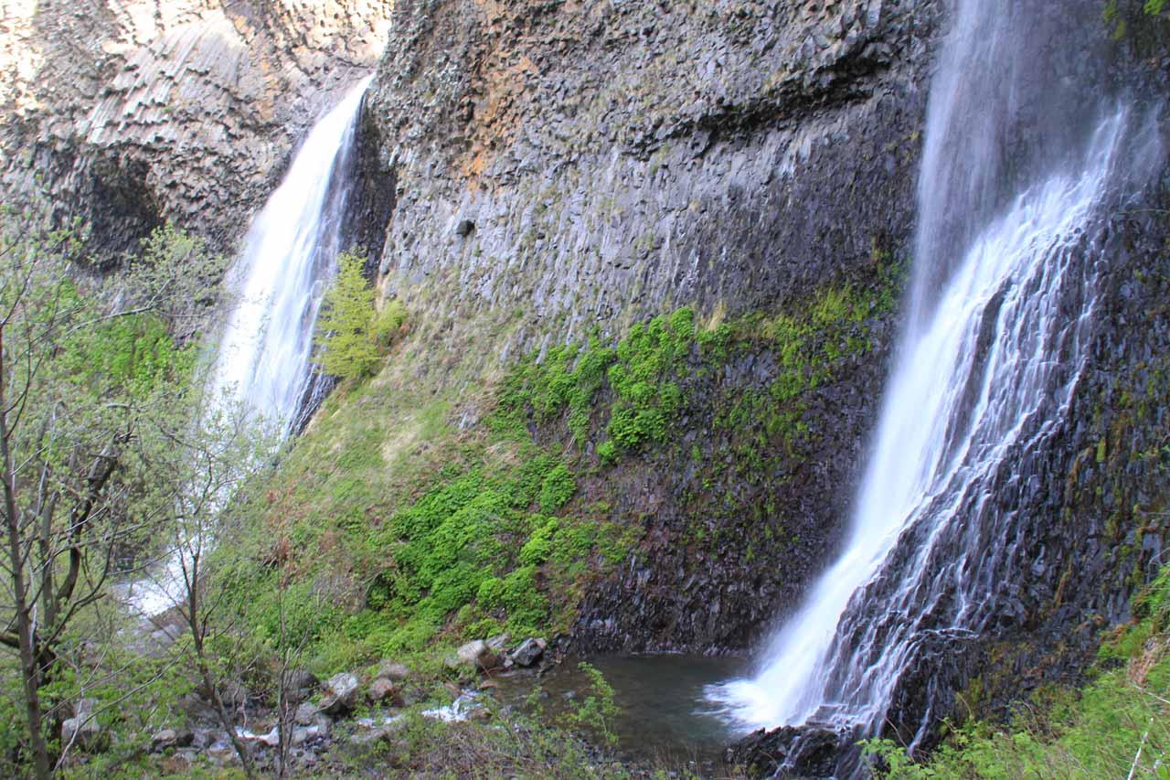
The Cascade du Ray-Pic ([RAY-peek]; “Ray Peak Falls”) was one of the more intriguing waterfalls we’ve seen. What made the roughly 60m falls interesting was that it was accompanied by prominent yet contorted basalt columns. The last time we saw waterfalls with such obviously conspicuous basalt features was in Iceland (namely Svartifoss and Litlanesfoss).

However, the Ray Peak waterfall also exhibited some geologic movement which gave rise to the bending of the basalt columns to the point that we could see the cross section of the columns to the upper left of the main waterfall. Our understanding of geology suggested that typically, basalt columns were indicative of the history of lava of a particular composition being rapidly cooled and solidified by ice (said to have occurred some 35,000 years ago according to the signs).

It was this geology that also caused the closure of the access to the base of the falls due to the rock fall danger from the overhanging basalt cliffs (most photos of the falls out in the literature were from this forbidden area). We were there when they pretty much finished a new walkway that avoided the base of the falls altogether and allowed us to see the falls from a pair of lookout platforms.

Ray-Pic_037_20120509
Pair of waterfalls comprising Cascade du Ray-Pic separated by cliffs of basalt as seen from the forbidden base
In high flow, the main waterfall can be accompanied by a thinner (but also impressive in its own right) waterfall. It was difficult to capture both waterfalls in one photo from the base, but one of the new overlooks gave us a pretty good view of both falls together. However, in the late morning, we had to look against the sun from this vantage point. So perhaps this may suggest that early to late afternoon may be better suited for viewing the falls from the better of the two official lookouts.

From the official car park, it took us about 15 minutes to walk to the overlook platforms and about an hour and 15 minutes to do the entire excursion including all the photo taking and relaxing. The trail was fairly easy without too much elevation change except for the end when we descended towards the lookouts down some steps.

Although this is not recommended and only if you’re willing to take risks while disobeying the signs, it is possible to hop the railing and continue on an old, steep trail towards the base of both falls. However if you do this, you need to be fully aware of the rock fall risks and understand why the authorities chose to close this means of access in the first place. In other words, your safety and your choices are solely your responsibility. That said, we did take some photos and videos from the base, which you can see further down this page.

One last thing worth mentioning is that we apparently stumbled onto a different trail leading to Cascade du Ray-Pic when we were driving away from here towards the natural bridge known as Pont d’Arc. This alternate trailhead (though I suspect it only led to the car park and didn’t provide a truly alternate access) was near an arched road bridge and featured a small cascade near it before following the stream along a sun-drenched gorge going in the upstream direction.

Ardeche_002_20120509
Ray-Pic_005_20120509
Ray-Pic_010_20120509
Ray-Pic_014_20120509
Ray-Pic_016_20120509
Ray-Pic_065_20120509
Ray-Pic_062_20120509
Ray-Pic_063_20120509
Ray-Pic_082_20120509
Ray-Pic_017_20120509
Ray-Pic_024_20120509
Ray-Pic_054_20120509
Ray-Pic_083_20120510
Ray-Pic_094_20120510
Ray-Pic_097_20120510


This rather off-the-beaten-path waterfall is said to be near the mountain village of Péreyres in the Ardèche department of the Rhône-Alpes region of Eastern France. There’s a lookout (Belvedere du Ray-Pic) as well as a car park further downhill from it, both of which are along the D215 between the communities of Burzet and Lachamp Raphaël.

Since we were staying in Lyon, we’ll describe the detailed driving directions as follows.

We left Lyon on the autoroute A7 going south through Valence and eventually leaving the autoroute A7 at the D104N exit between Loriol-sur-Drome and Le Pouzin. We then headed west on the D104 road for about 28km before keeping right onto the D122 road. Then, we followed the D122 for the next 28km when we then turned left onto the D215 at Lachamp Raphaël. Then, for the final 7km or so, we followed this road to both the overlook as well as the signposted trailhead a short distance thereafter near a hairpin turn. Overall, we did this as part of a long out-and-back day trip, but this part of the drive took us a little over 2.5 hours one-way.

Finally, for a bit of geographical context, the city of Lyon was 466km or at least 4.5 hours by car from Paris. However, we used the very fast and efficient TGV (high speed train or le train a grande vitesse), which wound up taking around 3 hours to cover this distance.

Find A Place To Stay

Focused on the pair of waterfalls from the lookout platform with the better view


U-shaped sweep taking in both of the cascades as well as basalt columns from the forbidden base

Related Top 10 Lists

No Posts Found

Trip Planning Resources


Nearby Accommodations


Tagged with: ardeche, rhone-alpes, ray-pic, france, waterfall, lyon, basalt


Visitor Comments:

Got something you'd like to share or say to keep the conversation going? Feel free to leave a comment below...

No users have replied to the content on this page


Share your thoughts about what you've read on this page

You must be logged in to submit content. Refresh this page after you have logged in.

Visitor Reviews of this Waterfall:

If you have a waterfall story or write-up that you'd like to share, feel free to click the button below and fill out the form...

No users have submitted a write-up/review of this waterfall


Have you been to a waterfall? Submit a write-up/review and share your experiences or impressions

Review A Waterfall

Nearest Waterfalls

The Waterfaller Newsletter

The Waterfaller Newsletter is where we curate the wealth of information on the World of Waterfalls website and deliver it to you in bite-sized chunks in your email inbox. You'll also get exclusive content like...

  • Waterfall Wednesdays
  • Insider Tips
  • User-submitted Waterfall Write-up of the Month
  • and the latest news and updates both within the website as well as around the wonderful world of waterfalls


How To Build A Profitable Travel Blog In 4 Steps