About Cascade d’Arpenaz
Cascade d’Arpenaz was a pretty easy and straightforward waterfall for us to see and visit as it was easily seen off the A40 autoroute. It was certainly one of the taller waterfalls we’ve seen in France as it’s said to be around 1200ft tall.
Perhaps what we remember most about this waterfall wasn’t so much its height, but its location. As we were cruising on the autoroute, we were only minutes away from a rest area and viewpoint of Mt Blanc (the highest point in France). And as we took the short detour to get close to the waterfall, we were struck by the beauty of the surrounding mountain scenery, which featured pointy peaks and towering cascades. In fact, there was another attractively tall cascading waterfall further north along the A40 though we didn’t stop for it.
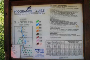
From the official car park for Cascade d’Arpenaz (see directions below), I took a path that led along the stream that the waterfall was on. There was a point where I had to cross the bitterly cold stream (socks off and wading in ankle-deep water in Chacos) in order to get a better view of the falls while allowing myself to get right up to its misty base.
In addition, we also enjoyed taking photos of the falls from several other vantage points that didn’t require getting wet. Among them were a picnic area where the waterfall towered over the foreground trees, a field of wildflowers just beyond the picnic area fronting the waterfall (see photo at the top of this page), and a distant viewpoint on the approach to the village of Luzier where we could see the entire context of the waterfall against its mountainous backdrop and fronted by a grassy valley populated with homes, farms, and power lines.
As for nomenclature, I’ve also seen this waterfall being referred to as Cascade de l’Arpenaz and the Arpenaz Waterfall. It is part of the Haute-Savoie department of the Rhône-Alpes region right in the heart of the French Alps in the country’s east.
Related Top 10 Lists
No Posts Found
Trip Planning Resources
Nearby Accommodations
This content is for members only. See Membership Options.Featured Images and Nearby Attractions
This content is for members only. See Membership Options.Visitor Comments:
Got something you'd like to share or say to keep the conversation going? Feel free to leave a comment below...No users have replied to the content on this page
Visitor Reviews of this Waterfall:
If you have a waterfall story or write-up that you'd like to share, feel free to click the button below and fill out the form...No users have submitted a write-up/review of this waterfall


