About Cascade d’Angon

Cascade d’Angon provided us the perfect waterfalling excuse for enjoying what we think was one of France’s “hidden” gems – the charming canal town of Old Annecy or La Vieille Ville d’Annecy. Just imagine something like France’s version of Venice mixed in with a picturesque alpine lake and that pretty much sums up what the Annecy experience would be like. But the waterfall itself allowed us to enjoy our time in Annecy that much more!
Being only about 30 minutes drive away from the charming canal town, we visited this waterfall attraction as a way to experience other parts of the neighboring Lac d’Annecy (Lake Annecy) region. After all, there was only so much strolling around and eating within Old Annecy that we could do in a day, so why not check out what else the beautiful area had to offer without breaking the bank?
Indeed, after finding the trailhead (see directions below), we hiked on a shaded and gradually descending path alongside some rural farms with a teasing view of the neighboring snow-crusted mountains towering over the scene (the same mountains that were backdrops to Lake Annecy making it so picturesque).
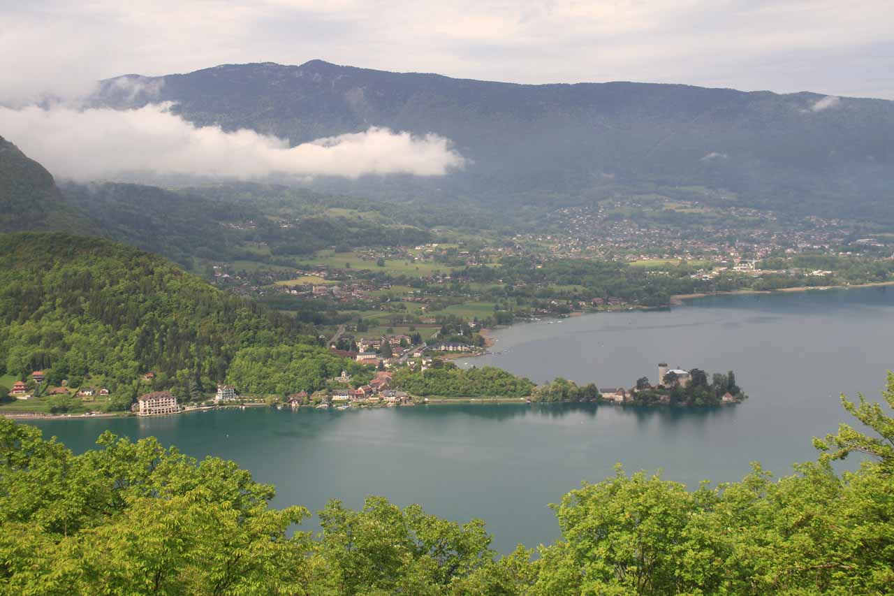
The trail was pretty benign with wide paths, lots of tree cover, and some rock step sections (where we had to be careful of the slippery footing thanks to the heavy rains during our visit). However, as we got further along the trail, we noticed there was one lookout through an opening in the foliage that provided us a view of some chateau jutting out to a peninsula on the southwestern part of Lake Annecy.
Continuing forward, the trail began to transition from the easy and tame trail to a more narrow cliff-hugging path that seemed to be cut right into the cliff itself. In a way, this half-sheltered cliff-hugging trail kind of protected us from the rain (at least before the weather started clearing up).
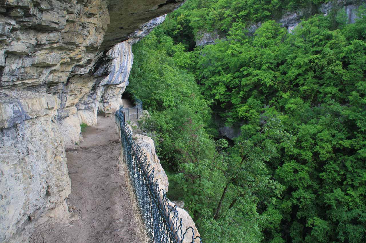
The trail got a bit steeper as it descended towards the head of the gorge it was hugging. It was at the head of this gorge where it became apparent that there were really two waterfalls coming together here!
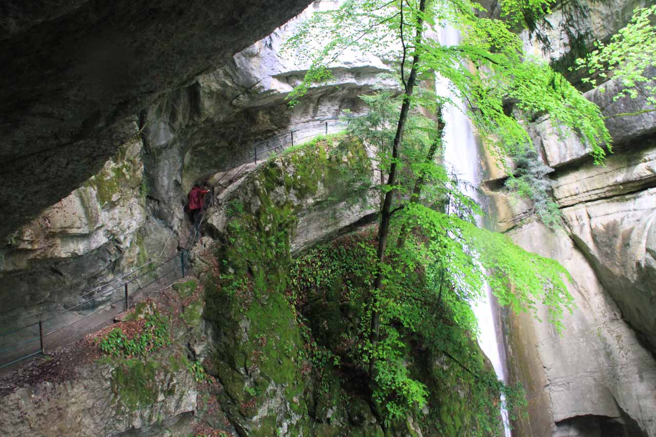
I’m not sure how permanent the first waterfall (on the left) was given its lighter flow relative to the second waterfall (on the right), which I suspect was the main Cascade d’Angon, which was said to be 35m tall. In any case, the slippery trail descended behind this first waterfall before climbing up to a little “nose” section where the trail momentarily left the overhead shelter of the cliffs above and allowed us to get attractive views back at this first waterfall while also getting partially obstructed views of the second waterfall.
The Cascade d’Angon represented the end of our hike and the turnaround point. It was difficult to get a clean look of the entire waterfall while en route to it given all the trees blocking the view. Plus, the tendency of this waterfall to drop right into a very narrow gorge made it difficult to get clean looks of its relatively concealed base. The net effect was that pictures didn’t do this waterfall justice as it always seemed to appear shorter than it really was.
From the very end of the trail, we could really feel the sense of vertigo as it was possible to peer up at the brink of the falls while also to peer down at the bottom of the falls (almost appearing like it dropped into a hole though it was really just a tight alcove). Further downstream, we could see another tier of that first waterfall joining the stream of this waterfall before the combined stream ultimately drained into the lake.
Another thing worth noting about Cascade d’Angon was that we noticed there was a chain and rope above this impossibly narrow and slippery-looking ledge. I believe the purpose of this was to make it possible to hang onto the rope-chain while precariously inching along the scary ledge to get right up to the waterfall and touch it. As both Julie and I saw this, we thought whoever has done this must have a death wish!
Finally, I have to add that even though the signs indicated it was only about a 20-minute hike in each direction, I think that time table only pertained to just getting to the first waterfall. It easily took us another 20-30 minutes of very slow and ginger walking (no thanks to the effects of rain and the resulting slippery surface) to go from the first waterfall to the second waterfall. So all things considered, it took us about two hours for the entire out-and-back hike, including all the time taken to enjoy the scenery and take lots of photos.
Related Trip Reports
Related Top 10 Lists
No Posts Found
Related Itineraries

Trip Planning Resources

Nearby Accommodations
This content is for members only. See Membership Options.Featured Images and Nearby Attractions
This content is for members only. See Membership Options.Visitor Comments:
Got something you'd like to share or say to keep the conversation going? Feel free to leave a comment below...No users have replied to the content on this page
Visitor Reviews of this Waterfall:
If you have a waterfall story or write-up that you'd like to share, feel free to click the button below and fill out the form...No users have submitted a write-up/review of this waterfall
Only logged in users can post a comment Please login or sign up to comment