Yahoo Falls

Big South Fork National Recreation Area, Kentucky, USA

About Yahoo Falls


Hiking Distance: 1 mile round trip (to base of falls); 2.6 miles round trip (to arch)
Suggested Time: 60-90 minutes

Date first visited: 2012-10-21
Date last visited: 2012-10-21

Waterfall Latitude: 36.77178
Waterfall Longitude: -84.51979

Waterfall Safety and Common Sense

Yahoo Falls maybe considered the tallest waterfall in the state of Kentucky at 113ft, but given its seasonal and light flowing nature, that title may still not warrant a visit unless there had been significant rainfall not long before that visit.

Such was the case during our excursion to this falls in late October. It was in a trickling state and required long exposure photographs to allow the thin falls to even show up in the pics. I’d imagine that a more reliable time to see this falls would be in the Spring. Even though I was lured by the thought of Autumn colors juxtaposed with the falls, it seemed like Fall just wasn’t very reliable for waterfall hunting.

During our visit, the direct path going down steps to its base was closed. So we actually had to hike a little longer than the reported 0.3 miles as we went over a creek crossing at the top of the falls, then walked past some additional underwhelming top down overlooks before descending some steep switchbacks towards the base. That descending path passed under some overhanging cliffs as it approached the large amphitheater with deep alcove at the bottom of the falls.

In addition to the readily available angled views of the waterfall from the trail, the trail kept going both into the alcove behind the waterfall as well as a separate one down a steep and slippery set of rock stairs that went directly to where the water from the falls hit the rocks at its base. I’d guess it was a minimum of 0.5 miles or so each way via the detour we were forced to take. I believe those trails that kept going would ultimately rejoin the closed off direct access path.

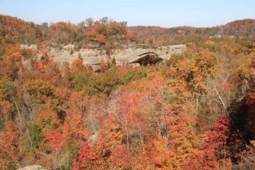
Despite the underwhelming performance of the falls, one thing it did have that was worth the diversion was the opportunity to check out a natural arch called Yahoo Arch. Even though it was on an out-and-back spur path (adding another 1.6 miles round trip to the existing hike to view Yahoo Falls), the intriguing arch had trees growing on its span, which was something I wasn’t used to seeing when it came to arches (especially those from the American Southwest).

Yahoo_Falls_023_20121021
Looking through the span of the arch
The spur path to the arch deviated from the main trail at a signposted junction just before the main trail descended to the base of Yahoo Falls via the detour we took. The arch trail generally went uphill before passing by a large alcove that preceded the arch itself. I recalled there was one somewhat confusing part of the trail where it seemed to disappear once it started to veer towards then away from a gurgling creek (I believe it’s a different creek than the one responsible for Yahoo Falls). The key was to look for a narrow trail that started its ascent (on the right looking away from the creek) to continue onwards to the arch.

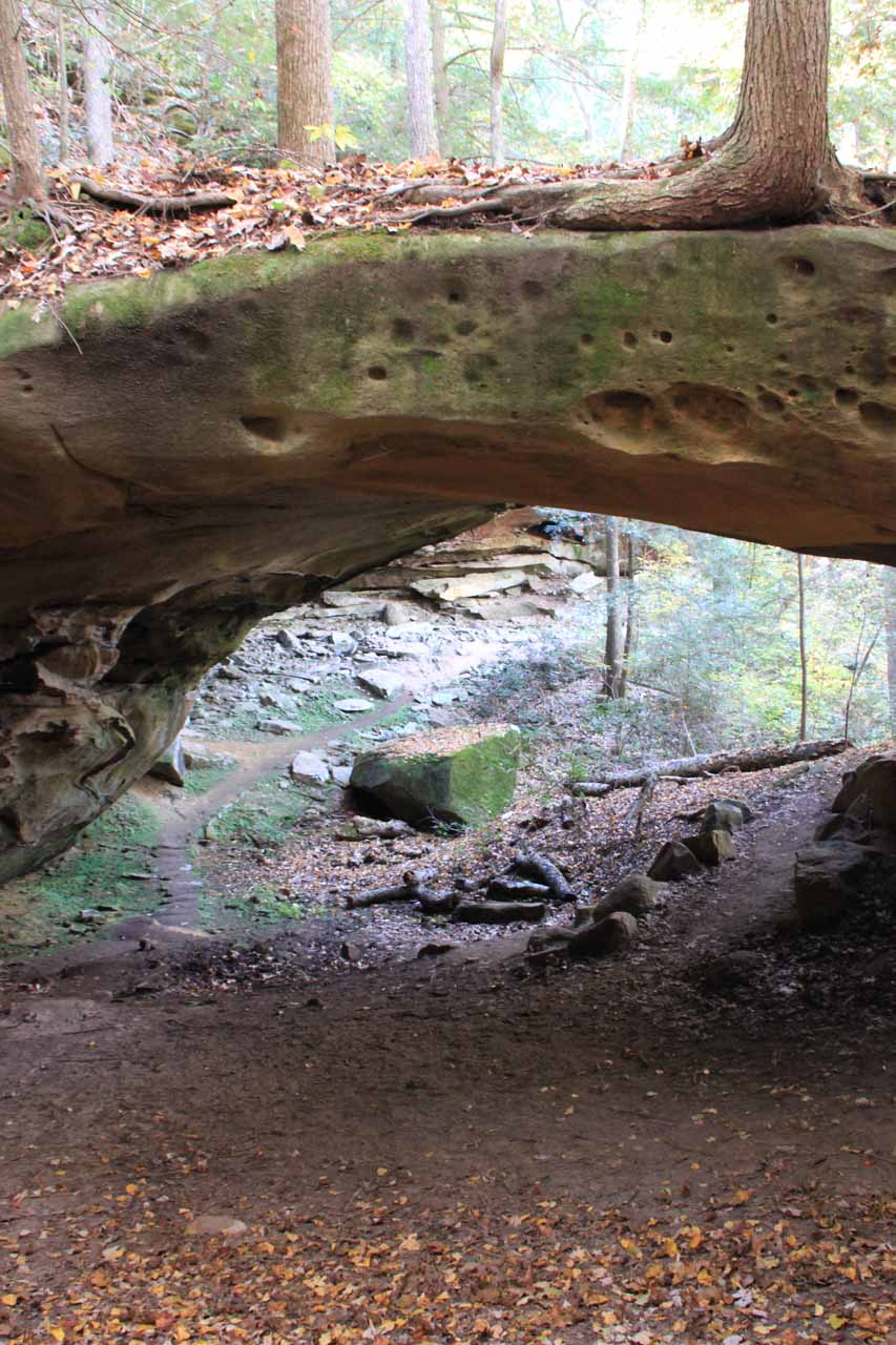
Once at the Yahoo Arch, I was able to walk through the underside of the long flat span, then I was able to scramble up towards the ledge on the far side of the arch where I could better appreciate the miracle of trees growing on the eccentric land bridge supporting them. There was some mild exposure to drop offs and muddy surfaces, but for the most part, it was relatively safe as long as the hazards were respected.

I believe the name of the falls and arch was a bastardization of a Native American word (possibly derived from the Muscogee people). It has nothing to do with the old internet search and web news company.

Yahoo_Falls_001_20121021
Yahoo_Falls_002_20121021
Yahoo_Falls_005_20121021
Yahoo_Falls_006_20121021
Yahoo_Falls_008_20121021
Yahoo_Falls_010_20121021
Yahoo_Falls_011_20121021
Yahoo_Falls_016_20121021
Yahoo_Falls_026_20121021
Yahoo_Falls_033_20121021
Yahoo_Falls_036_20121021
Yahoo_Falls_038_20121021
Yahoo_Falls_044_20121021
Yahoo_Falls_055_20121021


We came here from Cumberland Falls so we’ll describe how to get there using this as the starting point. Go to the Cumberland Falls page for directions on how to get there. Roughly speaking, it took around a half-hour to drive from Williamsburg to Cumberland Falls.

From the Cumberland Falls car park, continue west on Hwy 90 for about 2.7 miles. Turn left onto Hwy 700 (KY700) then follow this road past the US27 (about 11 miles from the US90/KY700 junction) towards Yahoo Falls Rd (15 miles from the US90/KY700 junction or 4 miles west of US27). Turn right onto the signposted Yahoo Falls Rd and follow this unpaved road for about 1.5 miles to the car park at its end.

Alternatively, the nearest town to the falls is Whitley City (at least according to my map). From this town, go north on the US27 for about 1.4 miles then turn left onto the KY700 and follow it for about 4 miles to the unpaved Yahoo Rd on the right.

The arch and waterfall were on their own little reserve even though it’s technically part of the Daniel Boone National Forest. It’s also been said to be part of the Big South Fork (of the Cumberland River), which encompasses parts of southern Kentucky and northern Tennessee.

Finally, for a bit of context, Williamsburg (the nearest town where we stayed) was 70 miles (over an hour drive) north of Knoxville, Tennessee, 183 miles (3 hours drive) northwest of Asheville, North Carolina, and 103 miles (over 90 minutes drive) south of Lexington.

Find A Place To Stay

Looking out the back opening of Yahoo Arch before panning over to look out the front opening


Backwards L-shaped sweep of the falls from its near side (from the trail we were able to access it from)


Bottom up sweep from directly in front of the falls

Related Top 10 Lists

No Posts Found

Trip Planning Resources


Nearby Accommodations


Tagged with: big south fork, national recreation area, mccreary county, daniel boone, national forest, yahoo arch, kentucky, waterfall


Visitor Comments:

Got something you'd like to share or say to keep the conversation going? Feel free to leave a comment below...

No users have replied to the content on this page


Share your thoughts about what you've read on this page

You must be logged in to submit content. Refresh this page after you have logged in.

Visitor Reviews of this Waterfall:

If you have a waterfall story or write-up that you'd like to share, feel free to click the button below and fill out the form...

No users have submitted a write-up/review of this waterfall


Have you been to a waterfall? Submit a write-up/review and share your experiences or impressions

Review A Waterfall

Nearest Waterfalls

The Waterfaller Newsletter

The Waterfaller Newsletter is where we curate the wealth of information on the World of Waterfalls website and deliver it to you in bite-sized chunks in your email inbox. You'll also get exclusive content like...

  • Waterfall Wednesdays
  • Insider Tips
  • User-submitted Waterfall Write-up of the Month
  • and the latest news and updates both within the website as well as around the wonderful world of waterfalls


How To Build A Profitable Travel Blog In 4 Steps