About Enbas Saut Falls

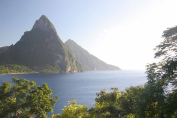
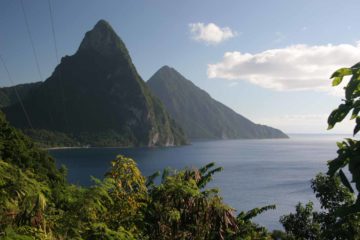
Enbas Saut Falls lies deep in the Edmund Forest Reserve, which is dominated by rainforest as they’re watched over by Morne Gimie (that’s “Jimmy” not “gimme”) and other surrounding mountains. The name of the falls means “underneath the falls” in French, and it might be because the water is said to be clean. We had this trail all to ourselves (except for the help of our guide Peter Simon) so it was quite a secluded spot to go for a cool swim for relief from the tropical heat.
A big reason why it was so quiet on this excursion was that we had to go on quite a bit of an adventure to get here.
First up was a pretty scary drive that I’d say would require a high clearance vehicle (and even then it was still scary; see directions below). Then, we had to hike a 4km loop that involved a bit of a hot and sweaty hike that started off with a lot of elevation loss and then ended with a long climb to regain that elevation while completing the loop hike. I believe it took us about 1.5-2 hours to do this hike.

While it was possible to visit Enbas Saut Falls on our own (there was a fee at the trailhead), it was not well signposted. We actually asked for directions at the nearby Diamond Botannical Gardens and ended up being accompanied by one of the tour guides who happened to be Peter Simon. I’ll leave it up to you whether you want to hire a guide or not.
From the trailhead, we descended down many steps that seemed to go on forever. We lamented this rather relentless descent because we knew that we had to climb back up at the end of the hike. Once we were at the bottom of the descent, we saw a pretty amusing sign with arrows pointing all over the place with each arrow pointing in the general direction of destinations from all over the world that tourists like us would’ve definitely identified.
Next, we meandered about more jungle as the path flattened out somewhat. I recalled we had to cross the stream a few times until we eventually made it to the secluded Enbas Saut Falls. We didn’t take time to swim here, but it looked like a pretty cool spot for a refreshing dip. Peter Simon showed us a few more lookout spots of the falls for different perspectives. I recalled there was also a picnic table here, which was pretty handy for acting as a kludgy tripod though it would’ve also been handy for picnicking in the peace and tranquility of this spot.
After having our fill of the falls, we were then guided above the falls where we saw a few more of its hidden tiers. Then, we continued on an alternate trail that climbed back up through a local farm before returning to the road at a different spot than where we started. As expected, this climb was relentless and long. So when we returned to the road, even though we still had a little bit more hiking to do on it, we definitely welcomed the flatter grade as well as the opportunity to check out the surrounding mountains.
Eventually, we returned to the trailhead and our parked rental car to complete the loop hike.
Related Trip Reports
Related Top 10 Lists
No Posts Found
Related Itineraries
Trip Planning Resources
Nearby Accommodations
This content is for members only. See Membership Options.Featured Images and Nearby Attractions
This content is for members only. See Membership Options.Visitor Comments:
Got something you'd like to share or say to keep the conversation going? Feel free to leave a comment below...No users have replied to the content on this page
Visitor Reviews of this Waterfall:
If you have a waterfall story or write-up that you'd like to share, feel free to click the button below and fill out the form...No users have submitted a write-up/review of this waterfall
Only logged in users can post a comment Please login or sign up to comment