About Waterfall Bay

Waterfall Bay typically referred to a body of water off the east coast of Tasmania on the rugged Tasman Peninsula. For the purposes of this page, I’m also using that term to refer to the 100m waterfall that would typically drop right into the Tasman Sea beneath Clemes Peak. However, as you can see from the photo above, that waterfall only left a dark stain on the sandstone cliff as it was trickling despite a couple of days of fairly heavy rains prior to our visit. That observation led me to believe that you’d have to come here after several episodes of heavy rains to at least let the seasonal creek saturate and support the waterfall and a possible companion to its right. The rains that preceded our visit in late November 2017 broke a fairly long 1-2 month stretch of unusually dry and warm conditions in Eastern Tasmania.
Julie and I were easily able to view Waterfall Bay from a trio of lookouts right at the end of the unsealed Waterfall Bay Road. While I’ve read that the authorities had been looking to close off the road, it was still open (albeit not well-signed) during our visit. Had the road been closed, then we would have had to walk 3km round trip starting from the Devil’s Kitchen and Tasman Arch area along a very scenic cliff-hugging stretch that would have taken in even more sea arches and temporary waterfalls. We’re keen to do this the next time we’re fortunate to visit this part of Tassie when the waterfalls would be flowing. This walk was said to take about an hour return.
Truthfully in hindsight, doing that track probably made the most sense because the Devil’s Kitchen, Tasman Arch, and the Blowhole were all sea cliff attractions that were worth visiting alone. In fact, the first time we visited the Tasman Peninsula back in early December 2006, we did just that, but we had skipped looking for waterfalls back then as we didn’t expect to see any waterfalls given the pre-conditioned mindset to expect drought conditions throughout that trip. The Waterfall Bay hike would add further icing to the cake so-to-speak while also leaving behind the tour buses and auto-tourists to the more famous roadside attractions. We just didn’t bother doing the whole hike due to time constraints after a late start to the day as well as the fact that the waterfall wasn’t flowing. Instead, we chose to do things the lazy way and drove over to the other end of the Waterfall Bay Track to save on time as we were visiting Port Arthur after having our fill of this area.
According to the signage at the Waterfall Bay Lookout, the pounding action of the Southern Ocean giving rise to the tall sandstone sea cliffs here had also carved out underwater caves that were said to be the most extensive cave system in all of Australia. Such underwater caves were said to harbour a variety of marine life like seadragons, sea fans, sponges, leather jackets, and well as many colourful fish in a scene more fitting of the Great Barrier Reef than the cool temperate waters of this bay. Julie and I had seen a pair of touring boats in the bay, which could very well have supported diving to take in those sights. By the way, the same erosive action that resulted in the underwater caves were also responsible for the Devil’s Kitchen (a totally collapsed sea cave), the very tall Tasman Arch (a mostly collapsed sea cave), and the Blowhole (a sea cave where most of its roof was intact).
Related Trip Reports

Related Top 10 Lists
No Posts Found
Related Itineraries

Trip Planning Resources


Nearby Accommodations
This content is for members only. See Membership Options.Featured Images and Nearby Attractions
This content is for members only. See Membership Options.Visitor Comments:
Got something you'd like to share or say to keep the conversation going? Feel free to leave a comment below...No users have replied to the content on this page
Visitor Reviews of this Waterfall:
If you have a waterfall story or write-up that you'd like to share, feel free to click the button below and fill out the form...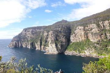 Waterfall Bay Tasmania April 11, 2015 6:14 am - Waterfall Bay is one of the most unique and beautiful waterfalling locations in Australia. The falls consists of very tall waterfall plunging into the sea, plus a couple of smaller falls further upstream. The main falls can be easily seen from a lookout at the start of the track, while the other two waterfalls are… ...Read More
Only logged in users can post a comment Please login or sign up to comment