Beehive Falls

Grampians National Park (Gariwerd) / Roses Gap / Wartook Valley, Victoria, Australia

About Beehive Falls


Hiking Distance: 2.8km round trip
Suggested Time: 60-75 minutes

Date first visited: 2017-11-15
Date last visited: 2017-11-16

Waterfall Latitude: -36.97424
Waterfall Longitude: 142.45211

Waterfall Safety and Common Sense

Beehive Falls was another one of the “minor” waterfalls within the Grampians National Park boundary where I happened to see it in two different personalities within a 24 hour period. Like with Clematis Falls, I happened to see this waterfall trickling prior to an overnight rain storm (the first significant rainfall in the area in at least a month) that caused me to return for a re-visit when I wound up seeing the 25m falls in a more satisfactory state. Given that it was a little out-of-the-way compared to most of the waterfalls in the Halls Gap vicinity (this one was in the Roses Gap area further to the north), I found myself completely alone both times I’ve done this hike so it was definitely fulfilling in terms of peace and quiet as well as letting Nature slowly sink into me during the excursion.

I’m unclear as to how Beehive Falls got its name, but I’m guessing that it might have come from the neighboring rock formations that could have resembled beehives to the people who named the falls. You can kind of see the potentially namesake mounds in the photo above, which I was able to attain only after continuing past the bottom of the falls on a steeply climbing track that eventually led up to the Briggs Bluff (another 4km past the falls). Without this perspective, the surrounding reddish cliffs took on a more jagged appearance as the “beehives” were set further back from the immediate cliffs blocking the line of sight to mounds.

Beehive_Falls_088_11152017
I was able to see Beehive Falls from a distance when the falls was flowing
The hike began from a well-signed car park and pullout right off the Roses Gap Road (see directions below). The mostly flat track meandered through open bushlands with limited tree cover (so it would be exposed to the sun on a sunny day) that might have seen a fire or two. This stretch persisted for the first 250m or so before the track made a bend to the right and the cliffs of the Briggs Bluff came closer into view. Then, the track followed alongside a gradually inclining path that more or less went straight for the next 600m. In this stretch, I was able to hear Mud Hut Creek (when it was flowing) as well as attain a distant view of Beehive Falls along with some Spring wildflowers that happened to be in bloom.

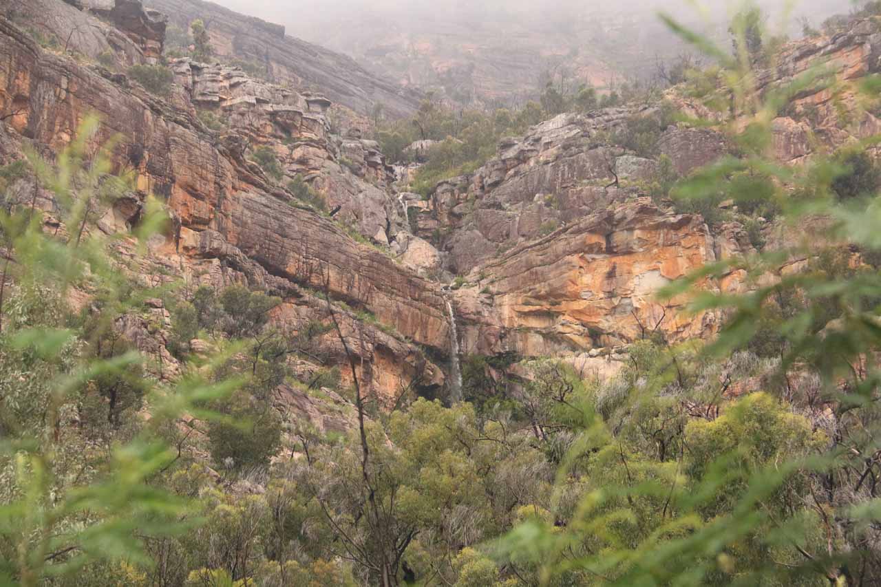
As the track brought me closer to the cliffs and they became more imposing, the path then veered to the left as it eventually brought me on a slight incline right up to the cliffs responsible for the Beehive Falls. After crossing a bridge over Mud Hut Creek, the path became a bit rockier (i.e. potentially more slippery) as it ascended rock steps and eventually deposited me past a small cave and right at the base of the impressive falls.

When I first showed up at the falls when it was trickling, I noticed that there were fish in the calm rocky plunge pool. I’d imagine that given the clarity of the water and the fairly secluded nature of the falls, it could very well be a cooling off spot on a hot day as evidenced by some informal scrambling tracks leading right up to the cliffs underlying the falls. Under conditions where there was more water on Mud Hut Creek (like on my return visit barely 24 hours later), this scramble and cooling off spot could be more hazardous as the rocks would be more slippery and the creek would be faster flowing.

Although the base of Beehive Falls was pretty much the turnaround point for this excursion (making this a 2.8km return hike), I actually noticed that the path continued back across Mud Hut Creek before climbing a series of rock steps. As alluded to earlier, it was from up there that I was able to look back at the falls for that unusual perspective that could very well have inspired its name. Both times I did this hike, I wound up taking about an hour each time.

Beehive_Falls_003_11142017
Beehive_Falls_008_11142017
Beehive_Falls_009_11142017
Beehive_Falls_025_11142017
Beehive_Falls_071_11142017
Beehive_Falls_140_11152017
Beehive_Falls_092_11152017
Beehive_Falls_027_11142017
Beehive_Falls_093_11152017
Beehive_Falls_095_11152017
Beehive_Falls_100_11152017
Beehive_Falls_036_11142017
Beehive_Falls_048_11142017
Beehive_Falls_111_11152017
Beehive_Falls_116_11152017
Beehive_Falls_062_11142017
Beehive_Falls_122_11152017
Beehive_Falls_134_11152017
Beehive_Falls_053_11142017


The signposted trailhead for Beehive Falls was right off the Roses Gap Road. There were two different approaches to get here, and which one you’d take depended on where you were coming from. So I’ll describe both methods in this section. I’ll start with the approach from Halls Gap (since that was where we were staying), then I’ll describe the route from the Western Highway between Horsham and Stawell.

From Halls Gap, I drove about 800m north of the C222/C216 junction (just north of the main part of town) to Mt Zero Road. Turning left onto the Mt Zero Road, I then drove for the next 20km or so to the Roses Gap Road. Most of this stretch of road was unsealed with lots of kangaroos (there was even a local cop patrolling this road) so I had to be careful not to overspeed.

Once I reached the paved Roses Gap Road, I then turned left and drove about 500m to the signed car park and trailhead on the left. Overall, this drive took me about 25 minutes.

Beehive_Falls_002_11142017
The unsealed Mt Zero Rd was unsealed and full of kangaroos when I took this approach to Beehive Falls from Halls Gap
For the other approach to the falls from the north, I’d recommend leaving the Great Western Highway (A8) at Jackmans Rd just east of the village of Dadswells Bridge. Dadswells Bridge was about 35km southeast of Horsham along the A8 from the A8/A200 junction and about 27km northwest of Stawell along the A8 from the A8/C216 junction (though from Stawell, you could just turnoff onto Roses Gap Rd directly).

Once on Jackmans Rd, I’d then drive it south for about 3km to the Roses Gap Rd. Then, I’d turn right and follow the Roses Gap Rd for a little over 6km to the signed car park and trailhead on the left.

Finally, while the realization that the Great Western Highway approach to the trailhead was all sealed and thus more appealing than the lengthy unsealed Mt Zero Road approach from Halls Gap, I did timed the all sealed route and it wound up taking me 35 minutes to do that drive due to the longer distance. So if I had to choose between going sealed or unsealed to and from Halls Gap, I’d still stick with the shorter unsealed approach.

For geographical context, Halls Gap was about 28km (under 30 minutes drive) west of Stawell, 75km (over an hour drive) southeast of Horsham, 50km (about 45 minutes drive) west of Ararat, and 96km (over an hour drive) north of Hamilton. Melbourne was roughly 205km (2 hours 15 minutes drive) east of Ararat and 300km (about 3.5 hours drive) east of Horsham.

Find A Place To Stay

Long video checking out the falls and surrounding cliffs in decent flow from both its sides while also looking up and down from those various angles. This was barely 24 hours after I saw it trickling prior to an all night rain storm


T-shaped sweep from left to right then following the path of the trickling waterfall

Related Top 10 Lists

No Posts Found

Tagged with: roses gap, mt zero, grampians, northern grampians, wartook valley, halls gap, horsham, victoria, austarlia, waterfall, gariwerd, mud hut creek


Visitor Comments:

Got something you'd like to share or say to keep the conversation going? Feel free to leave a comment below...

No users have replied to the content on this page


Share your thoughts about what you've read on this page

You must be logged in to submit content. Refresh this page after you have logged in.

Visitor Reviews of this Waterfall:

If you have a waterfall story or write-up that you'd like to share, feel free to click the button below and fill out the form...

No users have submitted a write-up/review of this waterfall


Have you been to a waterfall? Submit a write-up/review and share your experiences or impressions

Review A Waterfall

Nearest Waterfalls

The Waterfaller Newsletter

The Waterfaller Newsletter is where we curate the wealth of information on the World of Waterfalls website and deliver it to you in bite-sized chunks in your email inbox. You'll also get exclusive content like...

  • Waterfall Wednesdays
  • Insider Tips
  • User-submitted Waterfall Write-up of the Month
  • and the latest news and updates both within the website as well as around the wonderful world of waterfalls


How To Build A Profitable Travel Blog In 4 Steps