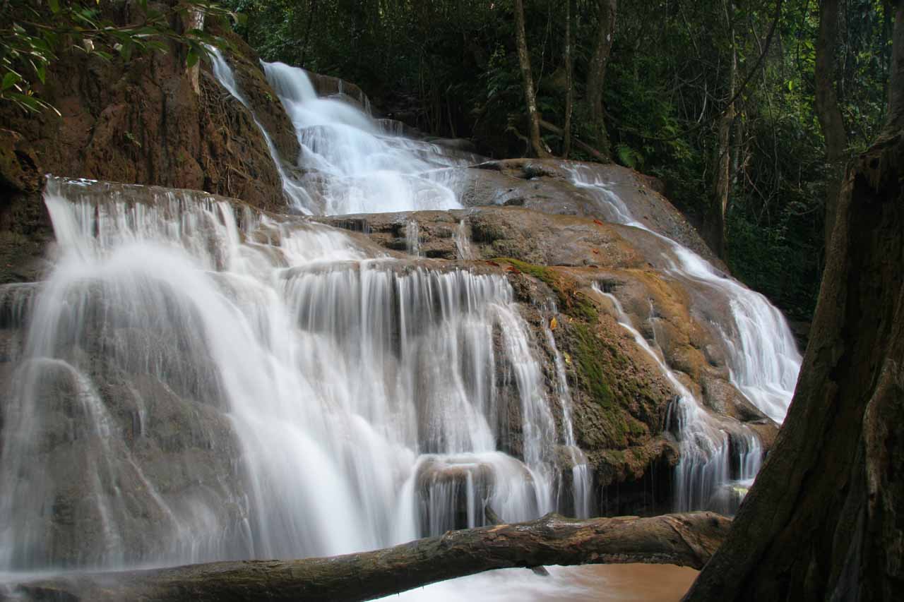
About Pha Charoen Waterfall (Nam tok Pha Charoen)

The Pha Charoen Waterfall (pronounced “PAH chah-RDOHN” [note the “r” is rolled]) was a lovely 97-level stair-stepping waterfall that was really photo friendly thanks to its combination of texture, size, and jungle setting. Needless to say, we really enjoyed photographing it with a tripod when the timing was right, which I’ll explain below.
Julie and I noticed that it was a fairly popular spot with the locals, and it was pretty easy to explore given that it was well-signed and had a very developed walkway to the viewing area at its base. But I guess it was its apparent popularity that did present photo challenges as many people would try to walk partway up the waterfall (right in front of the camera I might add) and linger in its cool waters.
It was possible that our visit coincided with a time when many Thais were on holiday, which might have amped up our perception of its popularity, but in general, the best time to photograph the falls would have to be early in the morning before the crowds arrive and before the sun would start creating bright and dark zones.
Once Julie and I (along with our guide Udon) got to the top of the falls, the trail flattened out and we witnessed a few more smaller cascades. We weren’t sure where this trail went nor how much further it went. Thus, when we thought the scenic allure diminished the further we went, we turned back not too far beyond the end of the steep climb. In total, we spent almost an hour for both the hiking and the photographing.
It was a welcome stop as we visited this waterfall while we were doing the long drive from Mae Sot to Umphang along the Death Highway (Hwy 1090). The Pha Charoen Waterfall was roughly 40 minutes south of Mae Sot. The waterfall actually sat in its own National Park, which featured other waterfalls and attractions. Unfortunately, we didn’t get a chance to explore this park more.
It turned out that there were also other attractions along the Death Highway, but we had only planned on visiting this waterfall and the Thararak Waterfall nearby.
Incidentally, we learned that the Death Highway earned its name from its completion which was said to have pacified frequent conflicts that had taken place up until the 1980s. Then, it kept its notoriety by becoming one of the most statistically accident-prone roads in the country thanks to its steep hills and winding roads. I recalled that we even had to help out a pair of ladies whose car had rolled backwards luckily into a ditch instead of into a dropoff!
Related Trip Reports

Related Top 10 Lists
No Posts Found
Related Itineraries
Trip Planning Resources
Nearby Accommodations
This content is for members only. See Membership Options.Featured Images and Nearby Attractions
This content is for members only. See Membership Options.Visitor Comments:
Got something you'd like to share or say to keep the conversation going? Feel free to leave a comment below...No users have replied to the content on this page
Visitor Reviews of this Waterfall:
If you have a waterfall story or write-up that you'd like to share, feel free to click the button below and fill out the form...No users have submitted a write-up/review of this waterfall
Only logged in users can post a comment Please login or sign up to comment