About Little Falls

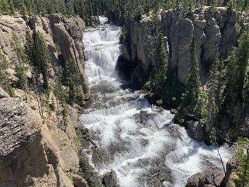
Little Falls was almost the waterfall that got away when I attempted to visit it right after doing the Mary Jane Falls hike. The problem was that the trail to access this waterfall wasn’t terribly obvious. In fact, on my first attempt, I managed to miss the correct trail entirely and I wound up finding a completely different waterfall. Even on the second attempt (once I saw a trail map at the Trail Canyon Trailhead nearby and knew where I was supposed to be walking), I was confronted with more misleading false trails and lack of signage pointing the way to the Little Falls, especially at the most critical junction (but plenty of signage keeping me on the Echo Trail). In any case, once I finally did find the waterfall, I had to slosh my way through a deep snowfield, and as you can see from the photo at the top of this page, that snow kept me from really benefitting from the fruit of my labor to get up to it. Indeed, this was an excursion that was way harder than it should have been (the difficulty score reflects this), and while it was good timing to see the more famous Mary Jane Falls further up the Kyle Canyon, it was still probably a couple months too early to see this 30ft waterfall. Thus, I’m sure a return visit is in order now that I know how to find this place, which I’m about to explain to you shortly.
I started the hike from the Echo Trailhead (see directions below). I just as easily could have started from the Cathedral Rock Trailhead, but I’ll only describe the Echo Trail route since that was how I did it. Immediately from the small parking area, there was signage pointing me to go right and following the dry wash briefly upstream. I had to pay close attention here because barely a minute later, there was another easy-to-miss trail sign on the opposite side of the wash pointing uphill to the left. This was the trail sign that I had missed on my first go, and it led to a long and difficult scramble nowhere near the Little Falls. So once I was on the correct trail, it ascended then flattened out for about the next 0.6 miles.
Along the stretch of correct trail, there were a couple of signs pointing me away from some false trails. There was a particularly insidious one where a sign saying “Echo Tr” was pointing to the left and right, but there was a wide path ascending steeply past the sign towards nothing in particular. Some confused hikers thought it was the trail to Little Falls, but gave up when it was apparent that it degenerated into a steep and difficult scramble. Meanwhile, I persisted and continued along the Echo Trail before it eventually junctioned with another unsigned trail on the right (this was the critical junction I alluded to earlier). The Echo Trail continued to the left, which would eventually lead to the Cathedral Rock Trailhead and the NV-157, but I didn’t need to go that way. So turning right and going up the unsigned trail, it would eventually ascend for the last 0.3 miles until the small canyon narrowed and the trail pretty much was within the creek supporting Little Falls. It was covered in snow during my visit in late April 2017. After rounding a corner when the canyon was already closed in, I was finally right in front of the falls, yielding the view you see at the top of this page.
Overall, this 1.8-mile round trip hike took me about an hour. It probably should have taken between 30-45 minutes given all the head-scratching I had to do to figure out which path to take when confronted with false trails. So that’s something to keep in mind when planning to visit this modest little waterfall. The benefit of doing this excursion was that it was far less busier than Mary Jane Falls and it provided gorgeous views across Kyle Canyon towards the Mt Charleston Village at the foot of the imposing Cockscomb Ridge.
Related Trip Reports
Related Top 10 Lists
No Posts Found
Related Itineraries
Trip Planning Resources
Nearby Accommodations
This content is for members only. See Membership Options.Featured Images and Nearby Attractions
This content is for members only. See Membership Options.Visitor Comments:
Got something you'd like to share or say to keep the conversation going? Feel free to leave a comment below...No users have replied to the content on this page
Visitor Reviews of this Waterfall:
If you have a waterfall story or write-up that you'd like to share, feel free to click the button below and fill out the form...No users have submitted a write-up/review of this waterfall
Only logged in users can post a comment Please login or sign up to comment