About Bridal Veil Falls

Bridal Veil Falls was said to be the tallest permanent free-falling waterfall in the state of Colorado at 365ft. Obviously when we first were made aware of the falls, it was high on our priority list. On top of that, we also learned that it was near the very scenic Alps-like ski-resort town of Telluride. So adding all these things together, we greatly anticipated a visit here when the opportunity presented itself as we decided to do a Desert Southwest trip to the Four Corner states, which included southwestern Colorado. However, as you can see from the photo above, our late April visit was a little on the early side in the season as there was still a lot of snow on the trail (more accurately a road) leading closer to the falls itself, and the falls was still mostly frozen. I had to look real close to see that there was indeed flowing water falling over the column of ice. So we’re probably due a return trip to this area to truly experience the falls as it should be, but even with the suboptimal conditions, I was still able to get a pretty satisfactory experience of the falls from afar (as this page in its current state would attest to).
From the pre-trip research, the hike to the private power station at the top of Bridal Veil Falls was said to be 3.6 miles round trip (1.8 miles each way). While the hiking distance may be modest, the elevation of the “trailhead” at over 9,000ft was no joke in terms of the potential for altitude sickness (no wonder why there was still a lot of snow here). But it turned out that if the vehicle can handle it (and you have the driving skills to maneuver the car up the narrowing road), it was possible to drive the switchbacking road up to the top of the falls. I managed to drive up to the third switchback before I encountered snow. And so I managed to get my views from there, but I decided against chancing it by hiking in the persistent snow to get further up the trail. It wasn’t like I had the motivation to keep going anyways since I was already able to view the falls from the so-called Valley View Area Parking (which was as far as passenger vehicles could go) as well as along the Colorado Avenue just beyond the main part of Telluride.
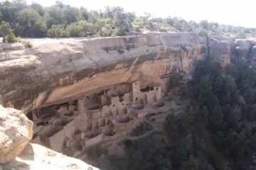
From the third switchback and beyond, I was already higher above the valley floor much of the trees. Plus, I was surrounded by impressive red cliffs on one side and snow-covered peaks on the other. Amongst the red cliffs were more ephemeral waterfalls. And when I looked back in the direction of Telluride, I could see the charming town flanked by a U-shaped valley providing evidence that a glacier which was once here carved it out in the pleasing manner that has made Telluride one of the premiere skiing and hiking spots in the Rocky Mountains. Obviously, I’m sure the views would be more dramatic and the views of Bridal Veil Falls would take on a different character had I been able to proceed, but that will have to be another time when I can complete this excursion and finally complete this write-up. Overall, I barely had to do any hiking as I had let the semi-high clearance vehicle do most of the work. As you can see in the difficulty score above, I pretty much treated this falls as a roadside attraction, as a result. I’m sure that will change once I finally get to hike closer to the falls.
On a loosely related note, I remembered an old Jeep TV Commercial years back where an attractive lady at a diner saw a guy she was interested in and dropped him a crumpled up napkin (making us think it was probably her phone number). But when the dude drove his jeep up a narrow cliff-hugging road and eventually wound up at a waterfall where she was there about to do a hike, we the viewer would find out she had scrawled GPS coordinates since “Jeep Wrangler owners speak their own language”. At the time, I had always wondered which waterfall it was that allowed you to drive up to its top like that, and I started to suspect it could be the Bridal Veil Falls in Telluride once I was finally made aware that this waterfall existed. Now that there’s youTube, I finally found the commercial and noted the GPS
coordinates, then put it on my Topo Map
, and lo and behold, it was indeed this waterfall! I don’t think I’ll be seeing “Jenny” up there, but I definitely look forward to coming back here to fully experience this excursion.
Related Trip Reports

Related Top 10 Lists
No Posts Found
Related Itineraries
Trip Planning Resources
Nearby Accommodations
This content is for members only. See Membership Options.Featured Images and Nearby Attractions
This content is for members only. See Membership Options.Visitor Comments:
Got something you'd like to share or say to keep the conversation going? Feel free to leave a comment below...No users have replied to the content on this page
Visitor Reviews of this Waterfall:
If you have a waterfall story or write-up that you'd like to share, feel free to click the button below and fill out the form...No users have submitted a write-up/review of this waterfall
Only logged in users can post a comment Please login or sign up to comment