About Lumangwe Falls
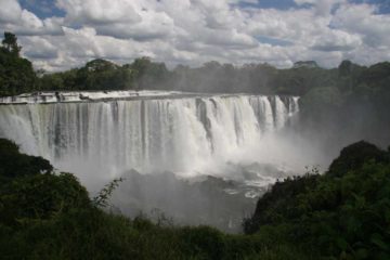
Lumangwe Falls was like a miniature Victoria Falls except this one was no slouch in its own right. It appeared to be roughly 30-40m tall and spanning a width of around 160m. But it had that wide rectangular shape that made this one of the more memorable waterfalls we saw in the remote Northern Zambia.
This waterfall was one of several waterfalls on the Kalungwishi River. Each waterfall on the river were attractions themselves with separate names. This was merely the first of the two that we saw though we were aware that there were four major ones on the river (the others were Chimpempe Falls, Kabwelume Falls, and Kundabwika Falls).
We definitely earned our view of this waterfall because it seemed that this part of the country (the Luapula Province) didn’t see many tourists. So consequently, the tourist infrastructure (e.g. road conditions, signage, etc) were either lacking or they were very basic. Even one of the signs indicating the turnoff to this falls was stolen! It also felt like we were one of the first and few to actually come out to see this waterfall.

Once at the car park, we noticed that there were a couple of main areas to view the waterfall. The first one we saw was a very misty lookout providing a very wide view of the entirety of the waterfall (see photo at the top of this page). It was from here that we could totally see why this might be thought of as a miniature Victoria Falls.
The second main lookout we saw was right by the brink of the waterfall, which was a short walk from the first lookout point mentioned above. From here, we got profile views and we really had to watch where we were standing in order that to avoid getting swept into the rushing river. At least from this vantage point, we weren’t at all bothered by spray from the waterfall, but the view was only limited to a small fraction of the overall width of the falls.
After seeing the falls from its brink, our guides Chanda, Joseph, and Chester took us down a very steep, rope-assisted descent down to the wide and misty plunge pool within the gorge. The area down here appeared to be flooded so probably happened to have seen the waterfall in high flow. Given the state of the plunge pool, we couldn’t go very far to even get a clean look at the waterfall from down here. The mistiness also ensured that there would be no way to photograph what it was like from this vantage point.
Just to give you an idea of the time commitment if you’re planning a trip here, we spent about 35 minutes away from the car. Of course, we could’ve easily spent much more time here, especially if there might have been less water so access to the base of Lumangwe Falls would have been more feasible than during our May 2008 visit.
Related Top 10 Lists
No Posts Found
Trip Planning Resources
Nearby Accommodations
This content is for members only. See Membership Options.Featured Images and Nearby Attractions
This content is for members only. See Membership Options.Visitor Comments:
Got something you'd like to share or say to keep the conversation going? Feel free to leave a comment below...No users have replied to the content on this page
Visitor Reviews of this Waterfall:
If you have a waterfall story or write-up that you'd like to share, feel free to click the button below and fill out the form...No users have submitted a write-up/review of this waterfall


