About High Force
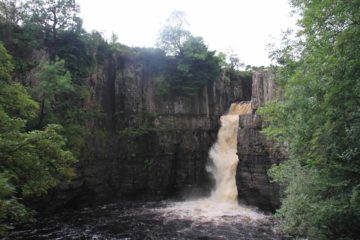
High Force impressed us with its gushing flow as it plunged 21m into a wide but turbulent plunge pool thanks to the River Tees flowing in full spate from all the unsettled weather that the area had been experiencing thanks to the remnants of Hurricane Bertha. Even without the help of a broken up hurricane, it seems that the river typically experiences powerfully reliable flow as almost all the photos I’ve seen of the falls in the literature tended to show the falls in a gushing state. Adding to its scenic allure were vertical cliffs flanking the funneling of the river over the waterfall while the plunge pool was fringed with jagged boulders that I’d imagine were once part of these cliffs. It was essentially Nature that was as raw and powerful as we’d encounter throughout England.
Our visit began from a large car park requiring a 2 pound fee to park the car (see directions below). Then, we had to pay an admission of 3 pounds total for both Julie and I as Tahia was able to tag along for free. Next, we had to cross the busy B6277 road (being extra cautious with Tahia given how quickly cars zoomed by here) before getting onto a wide, mostly open, and gently downhill trail that was flanked by some blooming wildflowers, some gorge walls, and some trees. To explain the open nature of the early part of the trail, a sign here informed us that this walk and the surrounding area ended up being cleared and destroyed by one of the most severe gales ever experienced in January 1992. Old growth softwoods over 100ft high were uprooted or blown over while the trail to the falls itself had to be re-built. In place of many of the old growth softwoods were imported exotic and commercial conifers, which I’d imagine explained the trees that we were seeing.

Eventually after another five minutes of walking, we then encountered stairs that brought us amongst the jumble of jagged boulders fringing the large plunge pool fronting High Force. It appeared that the trail continued to switchback further uphill before the stairs, but a sign there said a fence further ahead near the top of the falls was locked indefinitely due to safety issues. We didn’t pursue going to the top of the falls, but we did see quite a few people lingering up there so perhaps they hopped the fence anyways. But as for the base of the waterfall itself, the falls appeared to be shorter than what when we had seen it earlier on the trail. However, we still marveled at the geology lesson that literally was on display thanks to three noticeable layers of rock (said to be Whin Sill, Sandstone, and Limestone) comprising the cliffs flanking the falls.
A short distance further downstream, I also noticed what looked to be basalt-like formations on the cliffs across the River Tees. That would suggest to me there used to be some kind of interaction between lava and ice. In any case, as we were just chilling out amongst the jagged boulders fringing the plunge pool, we had to hold onto Tahia since there was nothing to keep her from getting dangerously close to the turbulent river. Overall, we spent a little over an hour doing both the hike and just relaxing at the falls (this didn’t include the 30 minutes or so of restroom time both before and after the hike given Tahia’s active bladder at the time).
Finally, a sign here talked about some of the reasons behind the place names we had been encountering while in the Yorkshire Dales, the Lakes District, and the Northern Pennines. It turned out that Vikings had settled in the area 1100 years ago, and with it, they left their linguistic mark on the culture and landscape with English-adopted vocabulary that was ultimately derived from Scandinavian words. For example, the word “force” came from the word “foss” meaning waterfall (something you’ll undoubtedly encounter in our waterfall writeups of Norway and Iceland). We also learned that several other words had Scandinavian roots as well such as “dale” from “dal” or valley, “gate” from “gata” or street, “beck” from “bekk” meaning brook, and “fell” from “fjell” meaning mountain.
Related Top 10 Lists
No Posts Found
Trip Planning Resources
Nearby Accommodations
This content is for members only. See Membership Options.Featured Images and Nearby Attractions
This content is for members only. See Membership Options.Visitor Comments:
Got something you'd like to share or say to keep the conversation going? Feel free to leave a comment below...No users have replied to the content on this page
Visitor Reviews of this Waterfall:
If you have a waterfall story or write-up that you'd like to share, feel free to click the button below and fill out the form...No users have submitted a write-up/review of this waterfall


Only logged in users can post a comment Please login or sign up to comment